[Editor’s Note: This is part 3 of the Grant County Commission work session that took place on Sept. 10, 2019.]
By Mary Alice Murphy
The work session of the Grant County Commission held on Sept. 10, 2019, heard public input mostly on the proposed Wild and Scenic designation, which can be read at http://www.grantcountybeat.com/news/news-articles/53238-grant-county-commission-hears-public-input-at-work-session-091019 and updates from Gila Regional Medical Center and Hidalgo Medical Services, which you can read at http://www.grantcountybeat.com/news/news-articles/53249-grant-county-commission-hears-updates-from-grmc-and-hms-at-work-session-091019-part-2.
Presentations continued with a proposal from the Silver City Cycling Group to create trails near Bataan Park. Martyn Pearson of Gila Hike and Bike and County Community Development and Planning Director Michael "Mischa" Larisch talked about the project.
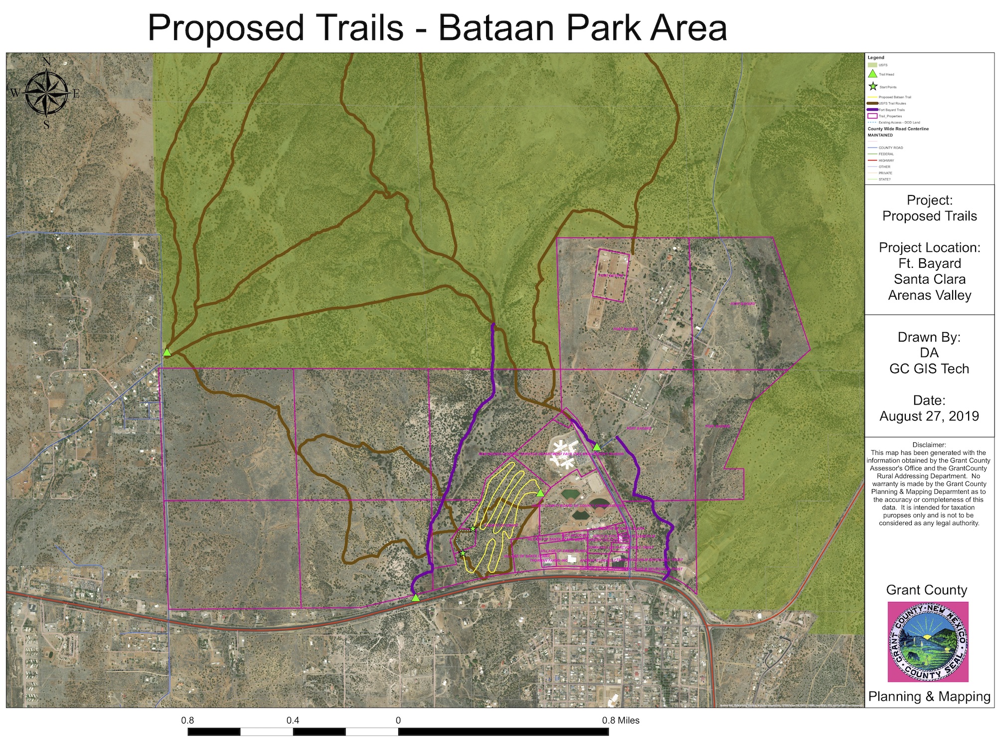 "We have trails going in on Boston Hill," Pearson said. "Where it's feasible, we put in new trails. The 60 acres across the road from Bataan Memorial Park and between there and Fort Bayard have two roads into them. The cross-country track students use the roads and a limited number of trails. They call the one hill, excuse my language, 'Puke Hill,' because it's so steep, rough and eroded. We thought we could do a lot with 60 acres to make a trail system to hike or ride to connect into the existing system at Fort Bayard."
He showed a map of the proposed trails and pointed out where the trails would run and where they could be accessed from where the roads come together.
Pearson said trail builder Doug Hewitt works to build private trails such as these. "He constantly looks at the ground. Although these have been mapped, he uses features to decide where to put a trail, so as to put in as much trail as possible, while having a lot of built-in drainage."
He said the group would fund the system, if the county allowed the groups to put the trails on the site, "with an agreement not to sell the area for 10 or 15 or more years."
Commissioner Harry Browne said the flip side of not developing the system would place the maintenance on the bike groups.
"It would be simple to maintain," Pearson said. "We can get into the area easily because we won't get rid of the roads. The cycling group has the manpower and will to maintain the trails."
Browne asked if it would be a public-private partnership.
County Manager Charlene Webb said she has considered something similar to that. "I'm not sure what it looks like yet, but I'm thinking about it."
Pearson said the cycling group has a volunteer agreement with the Gila National Forest. "We are working with Heart of the Gila to have training to guide trail work using the Forest Service standards. We're working on the educational piece."
Commissioner Alicia Edwards said, as Health Kids, Health Communities coordinator, "I've been having lots of conversations on this project and for bringing it to the commission. This trail could be used by the cross-country teams, so maybe we could get the school districts involved, too."
Larisch said Silver High School did maintenance and did eliminate Puke Hill. "On building and managing the trail system, including with the Forest Service and the county, we have met with the Cobre coaches. We're trying to maintain what the county put in at the request of the Cobre coaches. It didn't take drainage into account. Yes, the district will be interested in helping with the maintenance. For a meet, cross-country usually runs 2.8 to 3.2 miles."
Pearson noted that Hewitt puts in a mile for about every 10 acres, and he looks for firm land. Pearson pointed to areas on the map where it is probably too sandy for trails to be built.
Edwards said she was familiar with the trail building that Hewitt did on Boston Hill, which was excellent. "This will be a huge asset to the county and a great addition to everything we're trying to do with Bataan Park and Fort Bayard."
Pearson said when he got more involved with the Signal Peak Challenge in 2014, he inherited a mess. "A downhill community had taken it upon themselves to make changes to the trails. They weren't respecting the public use permit we had with the Forest Service. We had to fix a lot. The climbs had to stay in certain ascents and descents and the corners had to be not too steep or sharp to allow bicycles to go around them."
He also said that although it seems like the area has lots of trails for bicycling, "we can run out of them fairly quickly. As the father of an almost 11-year-old daughter and a 12-year-old son, who I'm happy to say enjoy bicycling, there are only a few areas that I would consider family-friendly. Our goal is to make this area family-friendly."
Commission Chairman Chris Ponce said he is passionate about Bataan Park and economic development through outdoor and indoor sports. "I would like to see a Bataan Park Community Center, maybe a rec center. Would this trail system impede development of a recreation center or other fields for soccer or football?"
"We did another map overlay," Larisch said. "There is already an outdoor education center, and we placed everything on the overlay map. We did look at a soccer field. I can produce the overlays for you."
Ponce said he didn't want to commit until he sees the full plan. "Bataan Park is a great place for the Mining District and even for Silver City. I want to make sure we don't step on any toes."
Pearson said Hewitt told him that the hardest land to build trail on is flat land, because of having to figure out how to get water off the trails. "There is certainly some stuff that is more desirable for trail and other areas for other development."
Ponce requested a walk in the area with Pearson to be able to visualize what is planned. Edwards said she, too, would like to walk the area.
"Yes, I'm willing to do that, any time," Pearson said.
Larisch said there was room in the plan for a track around a field in the center for soccer or football. "We also did an overlay for about 15 sites of an RV park."
Edwards said she thought the Santa Clara plan for Fort Bayard also includes an RV park. Larsich agreed, but said they put one in for cyclists, who generally like to camp near where they will ride.
The next presentation was from Gila National Forest Supervisor Adam Mendonca.
"I'm not here to tell you whether you should pass the wild and scenic river support resolution, but I came for more communication," Mendonca said. "What we are doing is not at all the same as what the environmental groups are proposing.
"We've spent 2½ years so far on the forest plan revision," Mendonca said. "What we do is eligibility and feasibility of wild and scenic stretches of the river. We are working parallel to the other effort, but we are not doing the same thing. They are very different processes. We looked at river stretches for their values of whether they are remarkable or outstanding. I think the forest service did an extensive effort and we will not make any recommendations for wild and scenic. We must make recommendations for wilderness, even if they are zero acres. For wild and scenic we don't have to make recommendations. Here's why my recommendation is for no recommendations. Our management has kept them remarkably outstanding. We will continue to manage them that way. What it leads me to is that I have had a chance to compare our analysis and theirs that you have in your proposal. They do not match. I can't show ours yet, but we will release it in January. It will include all our analysis, where we have gotten compared to their proposal, and they are very different. This proposal before you has many more miles of designation than we do in our inventory. When I looked at it and went with is that if everything is outstanding, nothing is. We have specific criteria for wild and scenic, and we set a high bar in our inventory. We have many fewer miles. I would encourage you to sit with the groups and understand their proposal and what criteria they used for it. If you wait until January, you can compare theirs and ours. Note that ours has a large public component."
He said there are three designations: recreational, scenic and wild. "If the right criteria are used, the designations should not impact current uses. One of our criteria was to look at different strains of Gila trout. Some areas have more important lineage. But fishing should not change. In contrast, if we look at the AWSA (Arizona Water Settlements Act) project and where it could potentially occur, if we know about it, we should not designate that stretch as wild and scenic. Different designations should be eligible for different needs. If you designate correctly for current uses, it does not account for future activities. For instance, if you designate as wild and scenic now, and in five years decide you need a diversion you may have an issue, so it is important to think about today and future uses. We designate for what we believe will happen on the stretches."
Mendonca noted that grazing is always a hot topic. "We have not used wild and scenic to remove cattle. Please note that we have received a notice of intent to be sued for overgrazing. I have to reply by this Friday. We can be sued for lots of things. Right now, we are on a timeline for this forest plan revision. It is dictated by our funding and our Washington office. Ours will be released in January. I'm here to give you an idea of how we designate. We work extensively with the community. We have met with the congressional delegation and the environmental groups. The one thing we most want to do is communicate with the community. We communicate with the congressional delegation and the groups, but they do not have to communicate with us."
Browne said he was "a little curious" as to what was behind the decision not to recommend wild and scenic designations. "I had never heard of the rationale behind your analysis, except for the management piece. You determined management is fine, so you don't need to do anything else?"
"We did an inventory and analysis in the early 2000s," Mendonca replied. "We started this process by comparing then and now. What we found was the inventory and analysis done was pretty good. There have been changes, such as the fire that impacted Willow Creek. The ash killed all the fish, so we put in a fish barrier and now you can fish Gila trout up through Willow Creek. Our inventory and analysis were good, and the only changes were where there were events, such as a couple of big fires. We have continued to manage the reaches to maintain their qualities. I made the decision early on pursuant to what the AWSA process was proposing then. It has changed, but I had made the decision to do all the required parts of the revision and stop when we completed the requirements."
Browne said to him the fact that management had been working was not a reason not to designate wild and scenic, but rather as a reason to designate to make sure it continues to be managed that way. "I feel it would be uncertain, if it weren't designated. The AWSA may have been the reason 10 years ago, but I don't see how it's a reason now, because there is no proposed diversion on forest service land."
"All we look at in our plan revision is forest service administered lands," Mendonca said. "Yes, the AWSA conversation was different from now, but I made the decision at the beginning of the plan revision process. You are correct that conversations have changed."
"Why can't you change it now?" Browne asked.
Mendonca said that because of the timeline and funding, it would be hard to finish the analysis in the time allotted. "We would be hard pressed to change it now. We receive funding of about $600,000 for the plan revision and the requirement is to finish within four years. Most revisions do not get completed within four years. We are coming close at 4½ years. We are the closest of all, as most are well over than four years."
Browne asked what the forest service took into account as "special. What is it compared to? Other parts of the Gila River, or the state or the country?"
"We looked at what is special in the Gila, using multiple criteria," Mendonca said. "One was the presence of threatened and endangered species and the other was recreational opportunities. If there was only one threatened or endangered species on a stretch, we did not consider it special. Some stretches have five, six or seven endangered or threated species that would make it special. We set a high threshold."
Browne said he felt in his mind that he could designate almost all stretches of the Gila, "because I compare them to the Gila outside of the forest."
Mendonca said the proposal in front of the commissioners has 440 to 450 miles of proposed designation. "Ours is closer to 150 miles."
Browne asked about the lawsuit, because it was his understanding that it was due to overgrazing.
"Groups are not enforcing the grazing rules," Mendonca said. "They aren't putting up enclosure fences, and in addition, we didn't have the Fish and Wildlife opinions. Feral cattle have been a major issue of the forest, which has been trying to address it for the past 20 plus years."
Browne said if allotments are managed correctly, it's OK, because it doesn't affect current use, but "I understand the potential for lawsuits."
Edwards asked a clarifying question about the process, timeline, funding so that the process is big and burdensome that even though circumstances have changes, "you can't afford to look at more analysis because you're too far along."
Mendonca said: "That's kind of correct. Will we make any recommendations on wild and scenic? No, because we made the decision early on not to recommend any wild and scenic stretches. It would be tough to go back on that decision."
Edwards said she was struck with the Gila National Forest trying to make decisions within the bureaucracies with no room to make changes due to changed circumstances.
Mendonca said the two most common ways for wild and scenic designations to be made are through the forest service plan revisions and through Congressional action. "There are other ways, such as the governor can get with the Secretary of the Interior and they can come to agreement. If outside the forest service, Congress decides to designate wild and scenic stretches, we will manage that way. We are governed by funding and law. The proposal in front of you won't go through the same process we do. We have big communications efforts to go through for our process."
Edwards asked how long the average tenure of a forest supervisor is. Mendonca said about five years, and "I've been here four and a half."
Edwards laughed and said: "I'm not suggesting we want to fire you. But it's challenging to work with a change of supervisor. You have a particular way to manage and it may not be the same as the next person."
Commissioner Billy Billings asked how wild and scenic would change "your ability to manage the forest?"
"If we designate correctly, we would have stretches as recreational and others as wild and scenic," Mendonca said. "That is what our analysis shows. When we recognize those uses, we wouldn't see changes in the future. Future proposals may not be able to be managed the same way. Future endeavors we may say no to. If something is designated other than the way we identified, it may have an impact on my management. If we say recreational and it goes wild or scenic, it may impact recreation. For our analysis, we have to go stretch by stretch to maintain the special features. If there are important reasons to designate and the designation makes sense, it would likely be because of the way we're doing things now. Designations may impact current and future management."
Edwards asked the difference between recreational and wild and scenic.
"There are three levels," Mendonca replied. "Each has a different management response. Recreational is the lowest tier and allows more management flexibility. It often includes fishing There may be stretches tied to floating the river. Scenic is the next level and has criteria for what can be allowed along the stretch. When I lived in Wyoming, a county wanted to put in a gravel pit near a scenic designation. It wasn't allowed because it could have been seen from the scenic stretch, but could have been put in, if it had been a recreational stretch. Wild is the highest tier and has more requirements."
The next article will address the preview of the regular session and will complete the work session series of articles.