 Southern Gila Highlands/Black Range-Southern Gila Foothills/Mimbres Valley-Southwest Desert/Lower Gila River Valley-Lowlands of the Bootheel-Uplands of the Bootheel-Southwest Desert/Mimbres Basin-Eastern Black Range Foothills-Northern Dona Ana County-Southern Dona Ana County/Mesilla Valley-Southern Tularosa Basin-
Western El Paso County-Eastern/Central El Paso County-
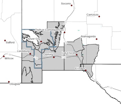
Including the cities of Silver City, Lake Roberts, Kingston,
Fort Bayard, Mimbres, Hurley, Faywood, Grant County Airport, Lordsburg, Red Rock, Virden, Antelope Wells, Animas, Hachita, Cloverdale, Deming, Columbus, Hillsboro, Winston, Garfield, Hatch, Radium Springs, Las Cruces, Vado, Sunland Park, Chaparral,Orogrande, White Sands Range Headquarters, Downtown El Paso, West El Paso, Upper Valley, East and Northeast El Paso, Socorro,
and Fort Bliss253 AM MDT Sun Apr 1 2018
...WIND ADVISORY IN EFFECT FROM 3 PM TO 9 PM MDT MONDAY...
The National Weather Service in El Paso Tx/Santa Teresa has
issued a Wind Advisory, which is in effect from 3 PM to 9 PM MDT
Monday.
* TIMING...Winds will increase in the early afternoon and attain
maximum values between 3 PM and 8 PM before slowly diminishing.
* WINDS...Winds will have sustained speeds around 30 mph with
gusts to near 50 mph. However stronger gusts are possible over
isolated locations, mainly through mountain passes and along
eastern slopes.
* IMPACTS...Blowing dust will reduce the visibility to less than a
mile over a few locations including along portions of Interstate
10 between El Paso and Las Cruces and also around Deming and
Lordsburg. Thus dangerous driving conditions are expected
especially for high profile vehicles.
The combination of strong winds and low humidity will also
create critical fire weather conditions.
PRECAUTIONARY/PREPAREDNESS ACTIONS...
A Wind Advisory means that winds of 35 mph are expected. Winds
this strong can make driving difficult, especially for high
profile vehicles. Use extra caution.