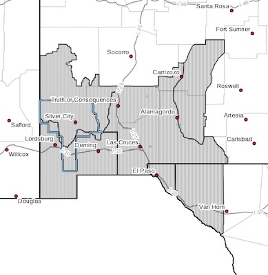
 New Mexico Fire Weather Zone 110 Southwest Mountains/gila Nf/apache Nf/glz-New Mexico Fire Weather Zone 111
Southwest Deserts And Lowlands/las Cruces Blm/glz-New Mexico Fire Weather Zone 112 South Central Lowlands And Southern Rio Grande Valley/blm/glz-New Mexico Fire Weather Zone 113 Capitan And SacramentoMountains/lincoln Nf/lnz-Texas Fire Weather Zone 055 El Paso County-texas Fire Weather Zone 056 Hudspeth County-
218 Pm Mdt Thu Apr 12 2018
...Red Flag Warning Remains In Effect Until Midnight Mdt TonightFor Critically Low Relative Humidity, Strong Winds, And Very HighTo Extreme Fire Danger For Fire Weather Zones 055, 056, 110, 111,112, And 113...
...Red Flag Warning In Effect From 10 Am To 8 Pm Mdt Friday For Critically Low Relative Humidity, Strong Winds, And Very High To Extreme Fire Danger For Fire Weather Zones 055, 056, 110, 111,112, And 113...
* AFFECTED AREA...All of Southwest and South Central New Mexico
and Far West Texas. This includes the Gila region, the
Sacramento mountains, the southwest and south central deserts
of New Mexico and the lowlands and peaks of Far West Texas.
* WIND...Southwest winds 35 to 45 mph with gusts to 60 mph through
this evening. Friday, west to northwest winds 25 to 35 mph with
higher gusts.
* HUMIDITY...7 to 12 percent. RH will be very slow to
recover...staying below 15 percent until midnight, with minimal
recoveries by Friday morning. Friday afternoon minimum relative
humidities 7 to 12 percent can be expected.
* IMPACTS...any fires that develop will likely spread very
rapidly. Winds of this strength may bring down weakened trees
and snags. Outdoor burning is not recommended.
PRECAUTIONARY/PREPAREDNESS ACTIONS...
A Red Flag Warning means that critical fire weather conditions
are either occurring now, or will shortly. A combination of
strong winds, low relative humidity, and warm temperatures can
contribute to extreme fire behavior.