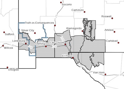
 Southwest Desert/Lower Gila River Valley-
Southwest Desert/Mimbres Basin-Northern Dona Ana County-
Southern Dona Ana County/Mesilla Valley-Southern Tularosa Basin-
West Slopes Sacramento Mountains Below 7500 Feet-
Sacramento Mountains Above 7500 Feet-
East Slopes Sacramento Mountains Below 7500 Feet-Otero Mesa-
Western El Paso County-Eastern/Central El Paso County-
Northern Hudspeth Highlands/Hueco Mountains-Salt Basin-
Including the cities of Lordsburg, Red Rock, Virden, Deming, Columbus, Garfield, Hatch, Radium Springs, Las Cruces, Vado, Sunland Park, Chaparral, Orogrande,
White Sands Range Headquarters, Mescalero, Timberon,
Mountain Park, Cloudcroft, Sunspot, Apache Summit, Mayhill, Pinon, Sacramento, Crow Flats, Downtown El Paso, West El Paso, Upper Valley, East and Northeast El Paso, Socorro, Fort Bliss, Hueco Tanks, Loma Linda, Cornudas, Dell City, and Salt Flat
349 AM MDT Tue May 1 2018
...WIND ADVISORY IN EFFECT FROM 2 PM TO 9 PM MDT WEDNESDAY...
The National Weather Service in El Paso Tx/Santa Teresa has
issued a Wind Advisory, which is in effect from 2 PM to 9 PM MDT
Wednesday.
* TIMING...Winds will increase through the late morning and early
afternoon and attain maximum speeds around 3 PM to 8 PM.
* WINDS...West to southwest winds will have sustained speeds
around 30 mph with gusts around 50 mph. Gusts may reach 60 mph
over very isolated locations mainly along eastern facing slopes
and mountain passes.
* IMPACTS...Blowing dust will reduce the visibility to less than a
mile over isolated locations including portions of Interstate 10
between El Paso and Las Cruces and also around Deming and
Lordsburg.
PRECAUTIONARY/PREPAREDNESS ACTIONS...
A Wind Advisory means that winds of 35 mph are expected. Winds
this strong can make driving difficult, especially for high
profile vehicles. Use extra caution.