Eastern Black Range Foothills NM-
Southern Gila Foothills/Mimbres Valley NM-
Southern Gila Highlands/Black Range NM-Uplands of the Bootheel NM-
Southwest Desert/Mimbres Basin NM-Lowlands of the Bootheel NM-
Southwest Desert/Lower Gila River Valley NM-
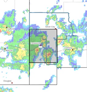
542 PM MDT FRI JUN 29 2018
...SIGNIFICANT WEATHER ADVISORY FOR SOUTHEASTERN GRANT...WESTERN LUNA
AND NORTHERN HIDALGO COUNTIES UNTIL 645 PM MDT...
At 538 PM MDT, Doppler radar was tracking scattered strong
thunderstorms moving around or over the vicinity of
Lordsburg...Separ...Hachita...Deming and City of the Rocks State
Park.
Pea size hail and winds in excess of 50 mph with blowing dust will
be possible with these storms. The blowing dust may lower
visibilities to under a quarter mile over a few locations resulting
in dangerous driving conditions.
Locations impacted include...
Animas, Cotton City, Sunshine, City Of Rocks State Park, Pyramid
Mountains, Jacks Peak, Hermanas, Windmill, Camp Ramsey, White Signal,
Steins, Playas, Carzalia Valley, Shakespeare, Rodeo, Lordsburg,
Granite Gap, Road Forks, Separ and Cookes Peak.
PRECAUTIONARY/PREPAREDNESS ACTIONS...
Torrential rainfall is also occurring with these storms, and may
lead to localized flooding. Do not drive your vehicle through
flooded roadways.
Southern Gila Foothills/Mimbres Valley NM-
Southern Gila Highlands/Black Range NM-
Southwest Desert/Mimbres Basin NM-Lowlands of the Bootheel NM-
Upper Gila River Valley NM-
Southwest Desert/Lower Gila River Valley NM-
523 PM MDT FRI JUN 29 2018
...SIGNIFICANT WEATHER ADVISORY FOR CENTRAL GRANT...WEST CENTRAL LUNA
AND NORTHWESTERN HIDALGO COUNTIES UNTIL 615 PM MDT...
At 519 PM MDT, Doppler radar was tracking showers and thunderstorms
over southwestern New Mexico around the Arizona border....Lordsburg
and Road Forks.
Winds in excess of 50 mph with Blowing Dust will be possible with
these storms. Areas of low visibility less than a quarter mile may
occur creating dangerous driving conditions including across
portions of Interstate 10.
Locations impacted include...
Animas, Cotton City, Mangas Valley, Pyramid Mountains, Tyrone Mine,
Virden, Jacks Peak, Redrock, Windmill, White Signal, Steins, Playas,
Shakespeare, Lordsburg, Granite Gap, Oak Grove, Tyrone, Road Forks,
Separ and Silver City.