


Weather
High Winds and Travel Advisory Issued for Southwest New Mexico
Expect Strong Winds, Snow, and Blowing Dust
DEMING - The New Mexico Department of Transportation (NMDOT) will be monitoring roadway conditions with local law enforcement over the next several days. If you must travel, we recommend you monitor local forecast conditions prior to starting your trip and visit our web site as roadway conditions may change quickly throughout New Mexico.
Roadway advisories will be posted on www.nmroads.com , or by calling 511. If you are approaching a dust storm or caught in a dust storm, please follow the guidelines below to help you stay safe.
On Thursday, February 1, 2024, High wind advisories were issued by the National Weather Service (NWS) (impacts attached from NWS with Press Release).
On Friday, February 2, 2024, the NWS is forecasting very strong winds from 20 to 30 mph and 3-5 inches of snow in the mountain areas.
On Saturday, February 3, 2024, the wind gusts are expected to increase to 25 to 35 mph with gusts up to 50 mph. The I-10 corridor could see low visibilities from blowing dust and mountain snow could create slick roadways.
The NMDOT would like to remind the traveling public, blowing dust can escalate to blinding dust storms as they move quickly through remote areas.
Avoid driving into or through a dust storm.
Do not wait until poor visibility makes it difficult to safely pull off the roadway — do it as soon as possible. Completely exit the highway if you can.
If you encounter a dust storm, check traffic immediately around your vehicle (front, back and to the side) and begin slowing down.
Do not stop in the roadway; pull completely out of the travel lanes and as far onto the right shoulder as possible.
Stop the vehicle in a position ensuring it is a safe distance from the main roadway and away from where other vehicles may travel.
Turn off all vehicle lights, including your emergency flashers.
Set your emergency brake and take your foot off the brake.
Stay in the vehicle with your seat belts buckled and wait for the storm to pass.
Drivers of high-profile vehicles should be especially aware of changing weather conditions and travel at reduced speeds.
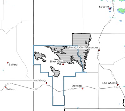
Removed: Difficult driving conditions on NM 15 and NM 152 012624
The Silver City Patrol has reported roadways around Silver City as clear and dry, removed from NM Roads.
ROAD ADVISORY
Difficult Driving Conditions in Silver City/Black Range Area
NM 152 is reported at snow packed & icy from milepost 15 (San Lorenzo) to milepost 40(Kingston). Please be sure to drive with caution, reduce speed, and follow all posted traffic signs. The NMDOT will continue to plow and monitor. This event will be updated as conditions change.
ROAD ADVISORY
Difficult Driving Conditions in Silver City/Black Range Area
NM 15 is reported at snow packed & icy from milepost 7 (Pinos Altos) to milepost 25(NM 35 junction). Please be sure to drive with caution, reduce speed, and follow all posted traffic signs. The NMDOT will continue to plow and monitor. This event will be updated as conditions change.
Winter Weather Advisory 1022-012424
 Southern Gila Region Highlands/Black Range-
Including the cities of Lake Roberts and Kingston
243 PM MST Mon Jan 22 2024
...WINTER WEATHER ADVISORY IN EFFECT FROM 11 PM THIS EVENING TO 5 AM MST WEDNESDAY...
* WHAT...Snow expected. Total snow accumulations of 4 to 6
inches.
* WHERE...Southern Gila Region Highlands/Black Range above 7000
feet.
* WHEN...From 11 PM this evening to 5 AM MST Wednesday.
Winter Weather Advisory 0121-012224
 Southern Gila Region Highlands/Black Range-
Including the cities of Lake Roberts and Kingston
405 AM MST Sun Jan 21 2024
Wind Advisory 011424
 Sacramento Mountains Above 7500 Feet-
East Slopes Sacramento Mountains Below 7500 Feet-
Southern Gila Region Highlands/Black Range-
Including the cities of Cloudcroft, Sunspot, Apache Summit,
Mayhill, Pinon, Sacramento, Lake Roberts, and Kingston
114 PM MST Sat Jan 13 2024
...WIND ADVISORY IN EFFECT FROM 8 AM TO 4 PM MST SUNDAY...
At least three Southwestern NM wind and dust advisories canceled 011124
 Upper Gila River Valley-Southern Gila Foothills/Mimbres Valley-
Southwest Desert/Lower Gila River Valley-Uplands of the Bootheel-
Eastern Black Range Foothills-Sierra County Lakes-
Central Grant County/Silver City Area-
Southern Gila Region Highlands/Black Range-
Including the cities of Cliff, Buckhorn, Gila Hot Springs,
Mule Creek, Hurley, Faywood, Grant County Airport, Lordsburg,
Red Rock, Virden, Cloverdale, Hillsboro, Winston,
Truth Or Consequences, Derry, Spaceport, Silver City, Mimbres,
Fort Bayard, Lake Roberts, and Kingston
435 PM MST Thu Jan 11 2024
...WIND ADVISORY IS CANCELLED...
The main punch of this winter storm system has moved past this
portion of the state. Winds will remain windy and gusty through
the evening, with some residual blowing dust still hanging in the
air through sunset, but conditions have improved, and will
continue to do so.
NM DOT road advisories for area 011124
ROAD ADVISORY
Difficult Driving Conditions in Silver City Area
The Silver City Patrol has reported roadways with light snow and could be icy. Please be sure to drive with caution, reduce speed, and follow all posted traffic signs. The NMDOT is out clearing roadways and will continue to monitor. This event will be updated as conditions change.
ROAD ADVISORY
Difficult Driving Conditions in Cliff Area
The Cliff Patrol is reporting all roadways as snow packed & icy. Please drive with caution, reduce speed, and obey all posted traffic signs. The NMDOT is out plowing and will continue to monitor roadways. This event will be updated as conditions change.
NMDOT High Wind Weather Advisory 011124-
HIGH WIND WEATHER ADVISORY:
According to the National Weather Service, this advisory will remain in most places through 9 p.m. tonight.
High wind warning in Hildago, Grant, Luna and Dona Ana Counties, visibility may be low in areas due to blowing dust. High profile vehicles please use caution. The NMDOT will continue monitoring the roadway. This event will be updated as conditions change.