 Southwest Desert/Lower Gila River Valley-Lowlands of the Bootheel-
Uplands of the Bootheel-Southwest Desert/Mimbres Basin-
Northern Dona Ana County-Southern Dona Ana County/Mesilla Valley-
Southern Tularosa Basin-
West Slopes Sacramento Mountains Below 7500 Feet-
Sacramento Mountains Above 7500 Feet-
East Slopes Sacramento Mountains Below 7500 Feet-
Western El Paso County-Eastern/Central El Paso County-
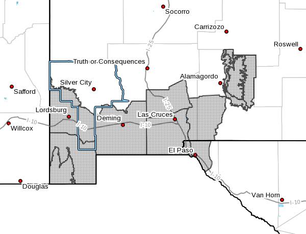
Including the cities of Lordsburg, Red Rock, Virden, Antelope Wells, Animas, Hachita, Cloverdale, Deming, Columbus,
Garfield, Hatch, Radium Springs, Las Cruc
Vado, Sunland Park, Chaparral, Orogrande, White Sands Range Headquarters, Mescalero, Timberon, Mountain Park, Cloudcroft, Sunspot, Apache Summit, Mayhill, Pinon, Sacramento, Downtown El Paso, West El Paso, Upper Valley, East and Northeast El Paso, Socorro, and Fort Bliss
552 AM MDT Sun May 26 2019
...WIND ADVISORY REMAINS IN EFFECT FROM NOON TODAY TO 7 PM MDT
THIS EVENING...
...WIND ADVISORY IN EFFECT FROM NOON TO 7 PM MDT MONDAY...
The National Weather Service in El Paso Tx/Santa Teresa has
issued a Wind Advisory, which is in effect from noon to 7 PM MDT
Monday.
* TIMING...Winds will increase around noon, with peak winds
between 3 and 6 PM.
* WINDS...Sustained speeds of 25 to 35 mph with gusts to 50 mph.
* IMPACTS...Windy conditions will make driving difficult,
especially for high profile vehicles. Loose objects may be blown
around. Areas of blowing dust could reduce visibilities to less
than 3 miles over some locations.
PRECAUTIONARY/PREPAREDNESS ACTIONS...
A Wind Advisory means that winds of 30 mph are expected. Winds
this strong can make driving difficult, especially for high
profile vehicles. Use extra caution.
A Wind Advisory means that winds of 35 mph are expected. Winds
this strong can make driving difficult, esp