 CRITICAL FIRE CONDITIONS EXPECTED SUNDAY FOR SOUTHWEST NEW MEXICO... .Winds will increase on Sunday ahead of an upper-level system, especially for areas west of the Continental Divide. Min RH values near 10% will combine with twenty-foot winds around 20 MPH along with ERC values in the 85-95th percentile to create low-end red flag conditions. Winds are expected to reach criteria around noon before diminishing after sunset.
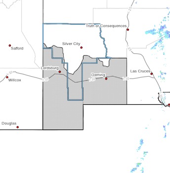
..RED FLAG WARNING IN EFFECT FROM NOON TO 9 PM MDT SUNDAY FOR
WARM, DRY, AND BREEZY CONDITIONS FOR SOUTHWEST NEW MEXICO...
...FIRE WEATHER WATCH IN EFFECT FROM MONDAY AFTERNOON THROUGH
MONDAY EVENING FOR WARM, DRY, AND BREEZY CONDITIONS FOR SOUTHWEST
NEW MEXICO...
The National Weather Service in El Paso Tx/Santa Teresa has
issued a Red Flag Warning, which is in effect from noon to 9 PM
MDT Sunday. A Fire Weather Watch has also been issued. This Fire
Weather Watch is in effect from Monday afternoon through Monday
evening.
* AFFECTED AREA...Fire weather zone 111.
* WIND...Around 20 MPH with gusts to 30 MPH.
* HUMIDITY...8 to 13 percent.
* IMPACTS...any fires that develop will likely spread rapidly.
Outdoor burning is not recommended.
PRECAUTIONARY/PREPAREDNESS ACTIONS...
A Fire Weather Watch means that critical fire weather conditions
are forecast to occur. Listen for later forecasts and possible
Red Flag Warnings.