


Weather
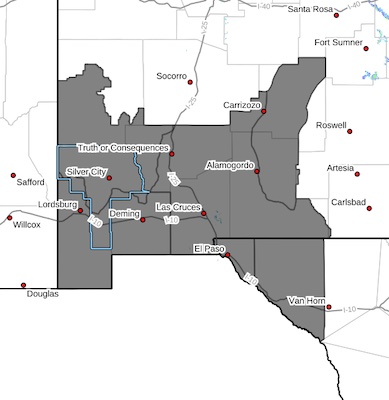
Wind Advisory 042724
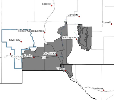 Southwest Desert/Mimbres Basin-Northern Dona Ana County-Southern
Dona Ana County/Mesilla Valley-West Slopes Sacramento Mountains
Below 7500 Feet-Sacramento Mountains Above 7500 Feet-East Slopes
Sacramento Mountains Below 7500 Feet-West Central Tularosa
Basin/White Sands-Western El Paso County-Eastern/Central El Paso
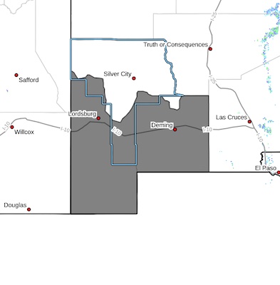
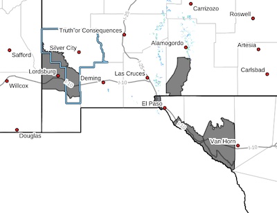
REMOVED: Severe Driving Conditions in Deming to Columbus
ROAD ADVISORY
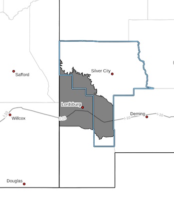
NM 11 is now open, removed from NM Roads.
Severe Driving Conditions in Deming to Columbus
NM 11 is closed at milepost 32 (O Kelley Rd) due to areas of severe dust causing black outs, visibility is limited. The NMDOT is on site monitoring and providing traffic control. Please drive with caution, reduce speed, and obey all posted traffic signs. This event will be updated as conditions change.
Critical to Extreme fire weather conditions today and Saturday - 042524 and 042724
 CRITICAL TO EXTREME FIRE WEATHER CONDITIONS ON THURSDAY... ... CRITICAL FIRE WEATHER CONDITIONS ON SATURDAY... .Deep southwest flow will continue to increase this afternoon with the passage of an upper level jet streak. Deep surface low over eastern Colorado will extend a strong pressure gradient southward into New Mexico and west Texas, leading to strong winds area wide during the daytime hours today. West-southwest winds with sustained speeds of 30 to 40 mph and peak gusts around 55 mph combined with very low relative humidity values will lead to critical fire weather conditions and the risk of rapid fire start and spread. Fuel moisture had dried rapidly this month, especially along the desert lowlands, due to preexisting drought status and lack of recent precipitation. Winds subsiding overnight into Friday morning, picking back up again Friday and Saturday afternoons. On Saturday, particularly, there is high confidence much of the south central and southwest New Mexico lowlands and far West Texas.
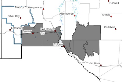
Blowing Dust Advisory-2 - 042524
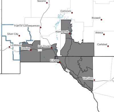 Southwest Desert/Mimbres Basin-Southern Dona Ana County/Mesilla
Valley-Otero Mesa-East Central Tularosa Basin/Alamogordo-
Southeast Tularosa Basin-Western El Paso County-Eastern/Central
El Paso County-Northern Hudspeth Highlands/Hueco Mountains-Salt
Basin-Southern Hudspeth Highlands-Rio Grande Valley of Eastern El
Paso/Western Hudspeth Counties-Rio Grande Valley of Eastern
Hudspeth County-
Blowing Dust Advisory- 1 through 7 p.m. 042524
 BLOWING DUST ADVISORY IN EFFECT UNTIL 7 PM MDT THIS EVENING...
* WHAT...Visibility between one-quarter and one mile in blowing dust
expected.
* WHERE...Southwest Desert/Lower Gila River Valley.
* WHEN...Until 7 PM MDT this evening.
Red Flag Warning; Critical Fire Weather conditions Thursday 042524
 CRITICAL FIRE WEATHER CONDITIONS ON THURSDAY... .Warm and dry high pressure will transition to deep southwest flow on Wednesday ahead of an approaching Pacific storm system that will move across the region on Thursday. Gusty southwest winds of 30 to 40 mph sustained with gusts of 50 to 60 mph, combined with critically low minimum relative humidity values will lead to critical fire weather conditions late Thursday morning into the evening timeframe.
Blowing Dust advisory 041524 -2
 Southwest Desert/Lower Gila River Valley-Southeast Tularosa Basin-
Western El Paso County-Southern Hudspeth Highlands-Rio Grande
Valley of Eastern El Paso/Western Hudspeth Counties-Rio Grande
Valley of Eastern Hudspeth County-
Including the cities of Virden, Sierra Blanca, Tornillo, Downtown
El Paso, West El Paso, Lordsburg, Red Rock, Fort Hancock, Fabens,
Upper Valley, Indian Hot Springs, and Orogrande
Mon Apr 15 2024
Blowing Dust Advisory 041524 -1
 Southwest Desert/Mimbres Basin-Southern Dona Ana County/Mesilla
Valley-Otero Mesa-Eastern/Central El Paso County-Northern
Hudspeth Highlands/Hueco Mountains-Salt Basin-
Including the cities of Dell City, Deming, Sunland Park,
Columbus, Las Cruces, Socorro, Fort Bliss, Loma Linda, East and Northeast El Paso, Hueco Tanks, Salt Flat, Cornudas, Vado, and Crow Flats
Mon Apr 15 2024
...BLOWING DUST ADVISORY IN EFFECT UNTIL 5 PM MDT THIS AFTERNOON...
...HIGH WIND WARNING REMAINS IN EFFECT UNTIL 10 PM MDT THIS
EVENING...