 .CRITICAL FIRE CONDITIONS EXPECTED THROUGH AT LEAST SATURDAY FOR SOUTHWEST AND SOUTH CENTRAL NEW MEXICO... Gusty winds each afternoon as strong winds aloft move across New Mexico. Min RH values will be between 6 and 14%, which will combine with 20 foot winds between 20 and 25 mph to create low to moderate red flag conditions this afternoon for all of southwestern and south central New Mexico.
South Central Lowlands and Southern Rio Grande Valley/BLM/GLZ-
Capitan and Sacramento Mountains/Lincoln NF/LNZ-
225 PM MDT Fri Jun 16 2023
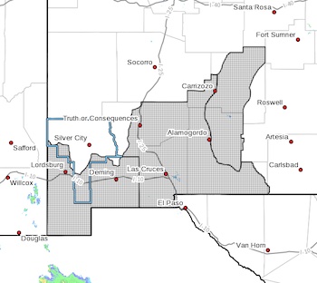
...RED FLAG WARNING IN EFFECT FROM NOON TO 9 PM MDT SATURDAY FOR
FOR SOUTHWEST AND SOUTH CENTRAL NEW MEXICO, INCLUDING FIRE
WEATHER ZONES 111, 112, AND 113...
The National Weather Service in El Paso Tx/Santa Teresa has
issued a Red Flag Warning, which is in effect from noon to 9 PM
MDT Saturday. The Fire Weather Watch is no longer in effect.
* AFFECTED AREA...All of southwestern and south central New
Mexico, including the Lincoln National Forest.
* WIND...20 to 25 mph with gusts up to 35 mph.
* HUMIDITY...6 to 14 percent.
* IMPACTS...Any fires that develop will likely spread rapidly.
Outdoor burning is not recommended.
PRECAUTIONARY/PREPAREDNESS ACTIONS...
A Red Flag Warning means that critical fire weather conditions
are either occurring now, or will shortly. A combination of
strong winds, low relative humidity, and warm temperatures can
contribute to extreme fire behavior.