 FIRE WEATHER WATCH IN EFFECT FOR SOUTHWEST NEW MEXICO ON FRIDAY DUE TO BREEZY SOUTHWEST WINDS... .Southwest flow aloft increases on Friday in response to a shortwave over Four Corners. Above normal temperatures and very dry air will combine with gusty southwest winds on Friday to create high fire danger. Sustained 20-ft winds of 20 to 25 mph will be possible with gusts up to 35 mph in the afternoon. Any fires that develop will have the potential for rapid fire growth.
NMZ11-113-221200-O.NEW.KEPZ.FW.A.0017.230623T1800Z-230624T0300Z
Southwest Mountains/Gila NF/Apache NF/GLZ-
Southwest Deserts and Lowlands/Las Cruces BLM/GLZ-
South Central Lowlands and Southern Rio Grande Valley/BLM/GLZ-
Capitan and Sacramento Mountains/Lincoln NF/LNZ-
609 AM MDT Wed Jun 21 2023
FIRE WEATHER WATCH IN EFFECT FROM FRIDAY AFTERNOON THROUGH
FRIDAY EVENING FOR GUSTY WINDS AND LOW RELATIVE HUMIDITY FOR FIRE
WEATHER ZONES 110, 111, 112, AND 113...
The National Weather Service in El Paso Tx/Santa Teresa has
issued a Fire Weather Watch, which is in effect from Friday
afternoon through Friday evening.
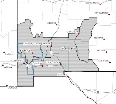
* AFFECTED AREA...Portions of southwest and south-central New
Mexico, including fire weather zones 110, 111, 112, and 113.
* WIND...Southwest 20 to 25 mph with gusts up to 35 mph.
* HUMIDITY...8 to 14 percent.
* IMPACTS...any fires that develop will likely spread rapidly.
Outdoor burning is not recommended.
PRECAUTIONARY/PREPAREDNESS ACTIONS...
A Fire Weather Watch means that critical fire weather conditions
are forecast to occur. Listen for later forecasts and possible
Red Flag Warnings.