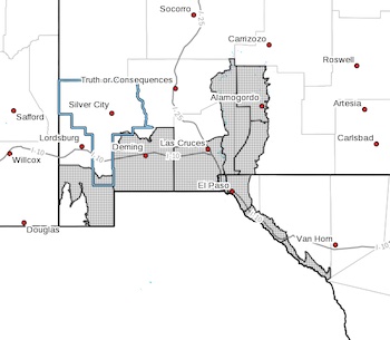
 Lowlands of the Bootheel-Southwest Desert/Mimbres Basin-
Southern Dona Ana County/Mesilla Valley-
West Central Tularosa Basin/White Sands-
East Central Tularosa Basin/Alamogordo-Southeast Tularosa Basin-
Western El Paso County-Eastern/Central El Paso County-
Rio Grande Valley of Eastern El Paso/Western Hudspeth Counties-
Rio Grande Valley of Eastern Hudspeth County-
Including the cities of Antelope Wells, Animas, Hachita, Deming,
Columbus, Las Cruces, Vado, Sunland Park,
White Sands National Park, Chaparral,
White Sands Range Headquarters, Alamogordo, Tularosa,
Holloman AFB, Orogrande, Downtown El Paso, West El Paso,
Upper Valley, East and Northeast El Paso, Socorro, Fort Bliss,
Fabens, Fort Hancock, Tornillo, and Indian Hot Springs
355 PM MST Thu Dec 21 2023
...DENSE FOG ADVISORY IN EFFECT FROM 3 AM TO 9 AM MST FRIDAY...
* WHAT...Areas of patchy fog with local visibility down to 1/4 to
1/2 mile in areas of dense fog.
* WHERE...Lowland and valley locations of south central and
southwest New Mexico and southwest Texas.
* WHEN...From 3 AM to 9 AM MST Friday.
* IMPACTS...Hazardous driving conditions due to low visibility.
* ADDITIONAL DETAILS...Fog is not expected to be as widespread, or
last as long as it on Thursday. However, some valley areas could
see visibility below 1/4 mile.
PRECAUTIONARY/PREPAREDNESS ACTIONS...
If driving, slow down, use your headlights, and leave plenty of
distance ahead of you.