 CRITICAL FIRE CONDITIONS EXPECTED SUNDAY FOR SOUTHWEST NEW MEXICO... ...CRITICAL FIRE CONDITIONS EXPECTED MONDAY FOR SOUTHWEST NEW MEXICO... .Winds are increasing this afternoon ahead of an upper-level system, especially for areas west of the Rio Grande Valley. Min RH values near 10% combine with 20 foot winds around 20 mph along with ERC values in the 85-95th percentile to create low-end red flag conditions. Winds are expected to diminish after sunset. On Monday, breezy conditions redevelop during the afternoon, setting the stage for another day of low-end red flag conditions for the lowlands of southern New Mexico. 20 foot winds will again be around 20 mph with gusts to 30 mph. Winds will subside after sunset Monday.
116 PM MDT Sun Jun 11 2023
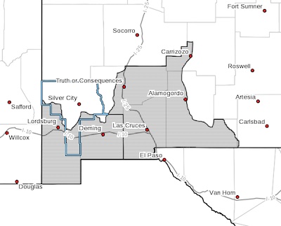
...RED FLAG WARNING REMAINS IN EFFECT UNTIL 9 PM MDT THIS EVENING
FOR WARM, DRY, AND BREEZY CONDITIONS FOR SOUTHWEST NEW MEXICO...
...RED FLAG WARNING IN EFFECT FROM NOON TO 9 PM MDT MONDAY FOR
WARM, DRY, AND BREEZY CONDITIONS FOR SOUTHWEST NEW MEXICO...
The National Weather Service in El Paso Tx/Santa Teresa has
issued a Red Flag Warning, which is in effect from noon to 9 PM
MDT Monday. The Fire Weather Watch is no longer in effect.
* WIND...West to southwest around 20 mph with gusts to 30 mph.
* HUMIDITY...7 to 10 percent.
* IMPACTS...any fires that develop will likely spread rapidly.
Outdoor burning is not recommended.
PRECAUTIONARY/PREPAREDNESS ACTIONS...
A Red Flag Warning means that critical fire weather conditions
are either occurring now, or will shortly. A combination of
strong winds, low relative humidity, and warm temperatures can
contribute to extreme fire behavior.