 CRITICAL FIRE CONDITIONS EXPECTED THURSDAY FOR SOUTHWEST NEW MEXICO AND FAR WEST TEXAS... Winds will increase on Thursday afternoon as an upper level system moves across New Mexico. Min RH values will between 6 and 14% combine with 20 foot winds between 20 and 25 mph along with ERC values in the 85-95th percentile to create low-end red flag conditions. Winds are expected to subside after sunset.
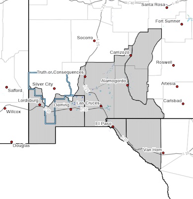
Southwest Deserts and Lowlands/Las Cruces BLM/GLZ-
South Central Lowlands and Southern Rio Grande Valley/BLM/GLZ-
Capitan and Sacramento Mountains/Lincoln NF/LNZ-
Texas Fire Weather Zone 055
El Paso County- Texas Fire Weather Zone 056
Hudspeth County-
1153 AM MDT Wed Jun 14 2023
...RED FLAG WARNING IN EFFECT FROM 1 PM TO 9 PM MDT THURSDAY FOR
FIRE WEATHER ZONES 055, 056, 111, 112, AND 113...
The National Weather Service in El Paso Tx/Santa Teresa has
issued a Red Flag Warning, which is in effect from 1 PM to 9 PM
MDT Thursday. The Fire Weather Watch is no longer in effect.
* WIND...West to southwest at 20 to 25 mph with gusts 40 mph.
* HUMIDITY... 6 to 14 percent.
* IMPACTS...Any fires that develop will likely spread rapidly.
Outdoor burning is not recommended
PRECAUTIONARY/PREPAREDNESS ACTIONS...
A Red Flag Warning means that critical fire weather conditions
are either occurring now, or will shortly. A combination of
strong winds, low relative humidity, and warm temperatures can
contribute to extreme fire behavior.