 CRITICAL FIRE CONDITIONS EXPECTED THURSDAY FOR SOUTHWEST NEW MEXICO AND FAR WEST TEXAS... Winds will increase on Thursday afternoon as an upper level system moves across New Mexico. Min RH values will between 6 and 14% combine with 20 foot winds between 20 and 25 mph along with ERC values in the 85-95th percentile to create low-end red flag conditions. Winds are expected to subside after sunset.
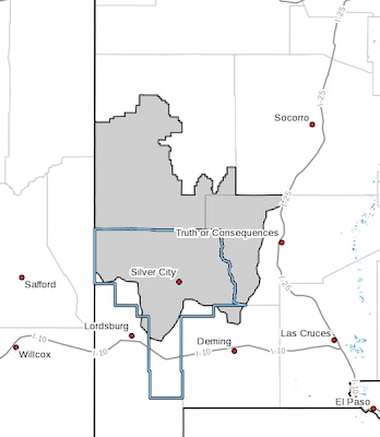
NMZ110-152200-
/O.NEW.KEPZ.FW.A.0015.230616T1800Z-230617T0300Z/
Southwest Mountains/Gila NF/Apache NF/GLZ-
214 AM MDT Thu Jun 15 2023
...FIRE WEATHER WATCH IN EFFECT FROM FRIDAY AFTERNOON THROUGH
FRIDAY EVENING FOR FIRE WEATHER ZONE 110...
The National Weather Service in El Paso Tx/Santa Teresa has
issued a Fire Weather Watch, which is in effect from Friday
afternoon through Friday evening.
* AFFECTED AREA...Fire weather zone 110.
* WIND... West at 20 to 25 mph with gusts up to 35 mph.
* HUMIDITY... 8 to 14 percent.
* IMPACTS...any fires that develop will likely spread rapidly.
Outdoor burning is not recommended.
PRECAUTIONARY/PREPAREDNESS ACTIONS...
A Fire Weather Watch means that critical fire weather conditions
are forecast to occur. Listen for later forecasts and possible
Red Flag Warnings.