 CRITICAL FIRE CONDITIONS EXPECTED THURSDAY THROUGH AT LEAST SATURDAY FOR SOUTHWEST NEW MEXICO AND FAR WEST TEXAS... Winds will increase each afternoon as an upper level system moves across New Mexico. Min RH values will be between 6 and 14%, which will combine with 20 foot winds between 20 and 25 mph along with ERC values in the 85-95th percentile to create low to moderate red flag conditions. Winds are expected to subside after sunset each evening. For Friday, critical winds are expected for the Gila and adjacent areas. For Saturday, critical winds are expected to spread across all New Mexico zones.
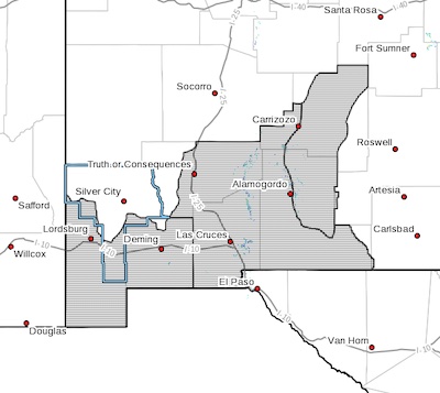
...RED FLAG WARNING REMAINS IN EFFECT UNTIL 9 PM MDT THIS EVENING
FOR FIRE WEATHER ZONES SOUTHWEST AND SOUTH CENTRAL NEW MEXICO...
...FIRE WEATHER WATCH IN EFFECT FROM SATURDAY AFTERNOON THROUGH
SATURDAY EVENING FOR SOUTHWEST AND SOUTH CENTRAL NEW MEXICO...
The National Weather Service in El Paso Tx/Santa Teresa has
issued a Fire Weather Watch, which is in effect from Saturday
afternoon through Saturday evening.
* WIND...West to southwest at 20 to 25 mph with gusts to 40 mph.
* HUMIDITY... 6 to 14 percent.
* IMPACTS...Any fires that develop will likely spread rapidly.
Outdoor burning is not recommended.
PRECAUTIONARY/PREPAREDNESS ACTIONS...
A Red Flag Warning means that critical fire weather conditions
are either occurring now, or will shortly. A combination of
strong winds, low relative humidity, and warm temperatures can
contribute to extreme fire behavior.
A Fire Weather Watch means that critical fire weather conditions
are forecast to occur. Listen for later forecasts and possible
Red Flag Warnings.