 CRITICAL FIRE CONDITIONS POSSIBLE SATURDAY AND SUNDAY... Gusty winds and very low relative humidities are expected for Saturday ahead of a strong upper level trough moving into the Rockies. West to southwest winds of 15-25 mph with gusts over 35 mph are possible in the Sacramento Mountains. These winds combined with single digit RH's and drying fuels will lead to critical fire weather conditions. A second day of gusty winds is expected on Sunday with winds of 15-25 mph, overspreading all of South Central and Southwestern NM, which will combine with very low relative humidities to create critical fire weather conditions. ERCs are relatively higher across the Gila National Forest, but with recent beetle die-off, the Gila is included within the Fire Weather Watch for Sunday.
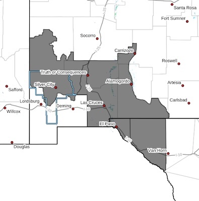
Southwest Mountains/Gila NF/Apache NF/GLZ-
South Central Lowlands and Southern Rio Grande Valley/BLM/GLZ-
Texas Fire Weather Zone 055 El Paso County- Texas Fire Weather Zone 056 Hudspeth County-331 AM MDT Fri Mar 13 2026
...FIRE WEATHER WATCH IN EFFECT FROM SUNDAY MORNING THROUGH
SUNDAY EVENING FOR GUSTY WINDS AND VERY LOW RELATIVE HUMIDITY FOR
PARTS OF SOUTH CENTRAL AND SOUTHWEST NEW MEXICO AND FAR WEST TEXAS...
* AFFECTED AREA...South Central New Mexico lowlands, Gila Region,
and Far West Texas
* WIND... Northwest winds 20-25 mph with gusts to 40 MPH
* HUMIDITY...7 to 11 percent
* HIGHEST THREAT... East Slopes of Area Mountains
* EXPERIMENTAL RFTI... 4 to 5 Marginally critical to critical
* IMPACTS...any fires that develop will likely spread rapidly.
Outdoor burning is not recommended.
PRECAUTIONARY/PREPAREDNESS ACTIONS...
A Fire Weather Watch means that critical fire weather conditions
are forecast to occur. Listen for later forecasts and possible
Red Flag Warnings.