








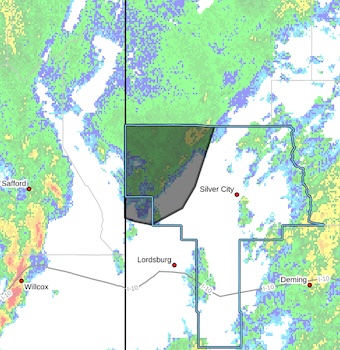
 Flash Flood Warning
National Weather Service El Paso Tx/Santa Teresa NM
337 PM MDT Tue Sep 29 2026
The National Weather Service in El Paso Tx/Santa Teresa has issued a
* Flash Flood Warning for...
Northwestern Grant County in southwestern New Mexico...
Northwestern Hidalgo County in southwestern New Mexico...
* Until 630 PM MDT.
* At 337 PM MDT, A band of moderate to locally heavy rain is
streaming across northern Grant and far northern Hidalgo County.
Flooding is likely to occur in several arroyos, creeks, and streams
in the area, and may travel into areas which received relatively
light rainfall.
HAZARD...Flash flooding caused by thunderstorms.
SOURCE...Radar and automated gauges.
IMPACT...Flash flooding of small creeks and streams, urban areas,
highways, streets and underpasses as well as other poor
drainage and low-lying areas.
* Some locations that will experience flash flooding include...
Cliff, Redrock, Mule Creek, Virden, Buckhorn, Riverside, Gila, Gila
Lower Box, Bill Evans Lake and Gila Middle Box.
PRECAUTIONARY/PREPAREDNESS ACTIONS...
Turn around, don't drown when encountering flooded roads. Most flood
deaths occur in vehicles.
Be aware of your surroundings and do not drive on flooded roads.
Remain alert for flooding even in locations not receiving rain.
Arroyos, streams, and rivers can become raging killer currents in a
matter of minutes, even from distant rainfall.