 CRITICAL FIRE WEATHER CONDITIONS FOR SOUTHERN NEW MEXICO ON FRIDAY... Thursday will set the stage as relative humidity values drop close to 5 percent and winds become breezy, resulting in elevated to near-critical fire weather conditions. Critically dry conditions continue, as winds further increase to windy Friday as an upper-level trough swings through the Rockies. West southwest winds increase to 15 to 25 mph during the day with gusts to 35 mph in the afternoon. Relative humidity values fall to about 10 percent on Friday. Widespread tree mortality and dieback fuels will increase the wildfire risk in both the Gila and Lincoln National Forests as ERCs climb back above the average, towards the 90th percentile through Friday.
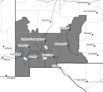
NMZ110 Southwest Mountains/Gila NF/Apache NF/GLZ-
Southwest Deserts and Lowlands/Las Cruces BLM/GLZ-
South Central Lowlands and Southern Rio Grande Valley/BLM/GLZ- Capitan and Sacramento Mountains/Lincoln NF/LNZ-
1047 AM MDT Thu Apr 16 2026
...RED FLAG WARNING IN EFFECT FROM NOON TO 8 PM MDT FRIDAY FOR
BREEZY WINDS AND LOW RELATIVE HUMIDITY FOR SOUTHWEST AND SOUTH
CENTRAL NEW MEXICO...
* AFFECTED AREA...Fire Weather Zone 110 Southwest Mountains/Gila
NF/Apache NF/GLZ, Fire Weather Zone 111 Southwest Deserts and
Lowlands/Las Cruces BLM/GLZ, Fire Weather Zone 112 South
Central Lowlands and Southern Rio Grande Valley/BLM/GLZ and
Fire Weather Zone 113 Capitan and Sacramento Mountains/Lincoln
NF/LNZ.
* TIMING...From noon to 8 PM Friday.
* WINDS...West 15 to 25 mph with gusts up to 35 mph.
* RELATIVE HUMIDITY...As low as 8 percent.
* TEMPERATURES...Up to 80.
* EXPERIMENTAL RFTI...3 to 5, or Near Critical to Critical.
* IMPACTS...any fires that develop will likely spread rapidly.
Outdoor burning is not recommended.
PRECAUTIONARY/PREPAREDNESS ACTIONS...
A Red Flag Warning means that critical fire weather conditions
are either occurring now, or will shortly. A combination of
strong winds, low relative humidity, and warm temperatures can
contribute to extreme fire behavior.