








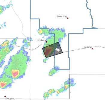
 BULLETIN - IMMEDIATE BROADCAST REQUESTED
Severe Thunderstorm Warning
National Weather Service El Paso TX
343 PM MDT Mon Oct 19 2026
The National Weather Service in El Paso has issued a
* Severe Thunderstorm Warning for...
Southern Grant County in southwestern New Mexico...
Central Hidalgo County in southwestern New Mexico...
* Until 430 PM MDT.
* At 343 PM MDT, a severe thunderstorm was located 10 miles south of
Lordsburg, moving east at 25 mph.
HAZARD...60 mph wind gusts and quarter size hail.
SOURCE...Radar indicated.
IMPACT...Hail damage to vehicles is expected. Expect wind damage
to roofs, siding, and trees.
* Locations impacted include...
Separ and Pyramid Mountains.
This includes Interstate 10 in New Mexico between mile markers 30 and
46.
PRECAUTIONARY/PREPAREDNESS ACTIONS...
For your protection move to an interior room on the lowest floor of a
building.
&&
LAT...LON 3208 10871 3225 10879 3236 10845 3217 10836
TIME...MOT...LOC 2143Z 249DEG 24KT 3220 10867
HAIL THREAT...RADAR INDICATED
MAX HAIL SIZE...1.00 IN
WIND THREAT...RADAR INDICATED
MAX WIND GUST...60 MPH