








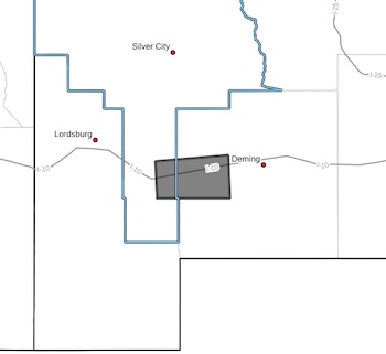
 [Editor's Note: It seems to be moving toward Deming, so you might try to be prepared.]
BULLETIN - EAS ACTIVATION REQUESTED
Severe Thunderstorm Warning
National Weather Service El Paso TX
456 PM MDT Mon Oct 19 2026
The National Weather Service in El Paso has issued a
* Severe Thunderstorm Warning for...
South central Grant County in southwestern New Mexico...
West central Luna County in southwestern New Mexico...
* Until 545 PM MDT.
* At 456 PM MDT, a severe thunderstorm was located 10 miles west of
Gage, moving east at 25 mph.
HAZARD...Two inch hail and 60 mph wind gusts.
SOURCE...Radar indicated.
IMPACT...People and animals outdoors will be injured. Expect hail
damage to roofs, siding, windows, and vehicles. Expect
wind damage to roofs, siding, and trees.
* Locations impacted include...
Gage.
This includes Interstate 10 in New Mexico between mile markers 48 and
72.
PRECAUTIONARY/PREPAREDNESS ACTIONS...
Remain alert for a possible tornado! Tornadoes can develop quickly
from severe thunderstorms. If you spot a tornado go at once into the
basement or small central room in a sturdy structure.
For your protection move to an interior room on the lowest floor of a
building.