

 Click to Search
Search
{{#data.error.root_cause}}
{{/data.error}}
{{^data.error}}
[{{{type}}}] {{{reason}}}
{{/data.error.root_cause}}
{{#data.hits.hits}}
{{#_source.featured}}
FEATURED
{{/_source.featured}}
{{#_source.showImage}}
{{#_source.image}}
 {{/_source.image}}
{{/_source.showImage}}
{{/_source.image}}
{{/_source.showImage}}
{{/data.hits.hits}}
{{{_source.title}}} {{#_source.showPrice}} {{{_source.displayPrice}}} {{/_source.showPrice}}
{{#_source.showLink}} {{/_source.showLink}} {{#_source.showDate}}{{{_source.displayDate}}}
{{/_source.showDate}}{{{_source.description}}}
{{#_source.additionalInfo}}{{#_source.additionalFields}} {{#title}} {{{label}}}: {{{title}}} {{/title}} {{/_source.additionalFields}}
{{/_source.additionalInfo}}

Latest News


Subscribe to the Update
- Category: Front Page News
By Lynn Janes
The Silver City Consolidated Schools held a work session and regular meeting January 20, 2026. Members in attendance included Ashley Montenegro, Michelle Diaz, Patrick Cohn, Mike McMillan and Kimberly Klement. Superintendent William Hawkins also attended.
Work session
During this work session they swore in the reelected board members. Matthew Runnells, magistrate judge came to swear in Montenegro, Diaz and Cohn. Runnells said he appreciated each one for serving but, "You can't have a full-time democracy with part-time citizenship."
Work session adjourned
Regular meeting started.
- Category: Front Page News
By Lynn Janes
The town of Bayard held a regular meeting January 21, 2026. Attendance included Mayor John L. Ojinaga, Eloy Medina (phone), Eloy Gonzales, Gilbert Ortiz and Charles Gray. Martha Salas, city clerk, also attended.
The council approved the agenda.
The mayor made his appointments for the next year with the approval of the council on all.
Mayor pro tem would be Eloy Gonzales this year. Ojinaga said he had made the change from Medina because Medina has so many other boards and commission responsibilities. He also serves as the EMS supervisor. Ojinaga felt he needed someone that would be available at a moment's notice. Gonzales had been on the council for three years and is retired so he had a lot more availability. Gonzales abstained from the vote.
- Category: Front Page News
By Lynn Janes
The Silver City Town Council held a regular meeting January 21, 2026. Attendance to the meeting included Mayor Simon Wheaton-Smith and councilors Nicholas Prince, Stan Snider and Victor Nanez.
The council approved the agenda for the meeting.
Council comments
Snider did not have a comment.
Nañez thanked the town for allowing him to attend the New Mexico Municipal League training in Santa Fe. He had some very valuable training from competent instructors and had learned a lot. He said Prince had asked significant questions in the training and had shown up in a tie and coat. He thanked the on call staff in maintenance, he had been made aware that they came after hours and did a fantastic job.
- Category: Front Page News
By Mary Alice Murphy
At the Grant County Commission first work session of 2026, Chair Chris Ponce, before everyone saluted the American Flag and the Flag of New Mexico, reminded everyone that it was the 113th anniversary of New Mexico statehood.
During public input, Bruce Ashburn, as state Rep. Luis Terrazas' aide, invited the commissioners and the public to a ribbon cutting on Jan 9 at the offices of Terrazas and state Sen. Gabriel Ramos in offices in the back of First American Bank on Swan Street.
[Editor's Note: You can see a photo and write up of the event at https://www.grantcountybeat.com/news/news-articles/sen-gabriel-ramos-and-rep-luis-terrazas-open-new-offices-010926 .]
Gila Regional Medical Center Board of Trustees Chair Dr. Fred Fox presented the monthly report to the commissioners. "I would like to present a review of last year. During this year, there was a successful transition to a new medical management advisory group."
- Category: Front Page News
By Lynn Janes
The town of Hurley had a regular meeting January 20, 2026. Mayor Reynaldo Maynes, Aron Phillips, Ester Gil and Robert Candelaria attended.
Maynes called the meeting to order.
The town of Hurley had received one letter of interest for the council position left open by Maynes. Robert Jason Cox had submitted a letter of interest.
Jason Cox said he had grown up in Hurley and lived there the majority of his life. Currently he works as the animal control officer for Grant County. At one time he had been the animal control officer in Hurley and owns a business in the town. He wants to see Hurley grow and head in the right direction.
- Category: Front Page News
By Frost McGahey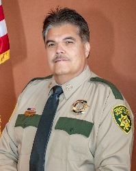 Sheriff Raul VillanuevaSheriff Raul Villanueva retaliated against his former deputy, Marcus Salas, for reporting the baby rabbit killing to the NM State Troopers. Yet, from the police report and video it is clear that Salas tried to protect the animal.
Villanueva claims that Salas failed to act, failed to report, and conduct unbecoming an officer. The Sheriff is using the accusations to prevent Salas from being hired by the NM State Troopers.
Villanueva fired Salas back in August 2025, but not content with that, filed a LEA 90 on September 10. With that complaint outstanding, the State Troopers can't hire Salas.
Here's a recap from the original police report:
On August 16, 2024 at 8:00 p.m. Deputy Salas decided to work overtime in the Hachita area. Deputy Gomez, Corporal Torres, and Sergeant Brandon Reese were also going to work there.
Page 16 of 151


Content on the Beat
WARNING: All articles and photos with a byline or photo credit are copyrighted to the author or photographer. You may not use any information found within the articles without asking permission AND giving attribution to the source. Photos can be requested and may incur a nominal fee for use personally or commercially.
Disclaimer: If you find errors in articles not written by the Beat team but sent to us from other content providers, please contact the writer, not the Beat. For example, obituaries are always provided by the funeral home or a family member. We can fix errors, but please give details on where the error is so we can find it. News releases from government and non-profit entities are posted generally without change, except for legal notices, which incur a small charge.
NOTE: If an article does not have a byline, it was written by someone not affiliated with the Beat and then sent to the Beat for posting.
Images: We have received complaints about large images blocking parts of other articles. If you encounter this problem, click on the title of the article you want to read and it will take you to that article's page, which shows only that article without any intruders.
New Columnists: The Beat continues to bring you new columnists. And check out the old faithfuls who continue to provide content.
Newsletter: If you opt in to the Join GCB Three Times Weekly Updates option above this to the right, you will be subscribed to email notifications with links to recently posted articles.
Editor's Notes
It has come to this editor's attention that people are sending information to the Grant County Beat Facebook page. Please be aware that the editor does not regularly monitor the page. If you have items you want to send to the editor, please send them to editor@grantcountybeat.com. Thanks!
Here for YOU: Consider the Beat your DAILY newspaper for up-to-date information about Grant County. It's at your fingertips! One Click to Local News. Thanks for your support for and your readership of Grant County's online news source—www.grantcountybeat.com
Feel free to notify editor@grantcountybeat.com if you notice any technical problems on the site. Your convenience is my desire for the Beat. The Beat totally appreciates its readers and subscribers!
Compliance: Because you are an esteemed member of The Grant County Beat readership, be assured that we at the Beat continue to do everything we can to be in full compliance with GDPR and pertinent US law, so that the information you have chosen to give to us cannot be compromised.
Submitting to the Beat
Those new to providing news releases to the Beat are asked to please check out submission guidelines at https://www.grantcountybeat.com/about/submissions. They are for your information to make life easier on the readers, as well as for the editor.
Advertising: Don't forget to tell advertisers that you saw their ads on the Beat.
Classifieds: We have changed Classifieds to a simpler option. Check periodically to see if any new ones have popped up. Send your information to editor@grantcountybeat.com and we will post it as soon as we can. Instructions and prices are on the page.