Fundraiser for GRIP July 24 and 25, 2026
Upcoming fundraiser for GRIP (Gila Resources Information Project) being hosted at MERGE art community space on July 24 and 25, 2026 See the attached poster,
 Click to Search
[{{{type}}}] {{{reason}}}
{{/data.error.root_cause}}
{{{_source.displayDate}}}
{{/_source.showDate}}{{{_source.description}}}
{{#_source.additionalInfo}}{{#_source.additionalFields}} {{#title}} {{{label}}}: {{{title}}} {{/title}} {{/_source.additionalFields}}
{{/_source.additionalInfo}}
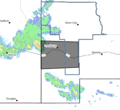 The National Weather Service in El Paso has issued a
* Dust Advisory for...
South central Grant County in southwestern New Mexico...
Northwestern Hidalgo County in southwestern New Mexico...
* Until 300 AM MDT.
* At 205 AM MDT, an area of blowing dust was over Lordsburg.
HAZARD...Less than one mile visibility with strong winds up to 45
mph.
SOURCE...Law enforcement.
IMPACT...Hazardous travel.
This area of blowing dust will remain over mainly rural areas of
south central Grant and northwestern Hidalgo Counties.
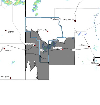 Southwest Desert/Lower Gila River Valley-Lowlands of the Bootheel-
Southwest Desert/Mimbres Basin-
Including the cities of Virden, Animas, Hachita, Lordsburg,
Deming, Red Rock, Antelope Wells, and Columbus
737 AM MDT Sat Jul 11 2026
...BLOWING DUST ADVISORY IN EFFECT FROM 4 PM THIS AFTERNOON TO 9 PM MDT THIS EVENING...
* WHAT...Visibility between one-quarter and one mile in blowing dust expected from thunderstorm outflows. Winds may gust as high as 70 MPH with the strongest storms, creating near zero visibility in localized areas. Dust Storm Warnings will be issued as necessary.
* WHERE...Lowlands of the Bootheel, Southwest Desert/Lower Gila River Valley, and Southwest Desert/Mimbres Basin.
Press Release – July 11, 2026
Precipitation Aids Containment on Sacaton Fire
Acres: 9737 Start Date: June 21, 2026
Location: 15 miles east of Glenwood, NM Personnel: 161
Containment: 43% Cause: Lightning
Summary: Fire crews made steady progress on Friday, supported by light precipitation over the entire fire area and helicopter bucket drops. Crews completed preparation work on the Bearwallow Road. Along the 119 Road crews improved road access using a dozer. At Willow Creek, the structure protection group finished removing accumulated slash and logs to maintain road access and reduce flood risk. Areas of remaining heat were observed near Black Mountain and north of Turkeyfeather Mountain.
Today, crews are reducing vegetation along Bearwallow Road by hauling slash created during earlier preparation work. Initial attack resources remain ready to assist other divisions and respond promptly to any new fire starts.
HIGH WIND WEATHER ADVISORY:
High wind warning in Hildago and Luna Counties, visibility is low in areas due to blowing dust. High profile vehicles please use caution. The NMDOT will continue monitoring the roadway. This event will be updated as conditions change.
REMOVED: ROAD ADVISORY
ALERT- Lordsburg Playa Area
Difficult Driving Conditions, I 10 eastbound and westbound lanes from mile marker 5 (Steins) to 15 (Gary) will have officers slow rolling traffic due to dust and low visibility.
[Editor's Note: I'm guessing you should get used to this every day for a few months!]
 Severe Thunderstorm Warning
National Weather Service El Paso TX
439 PM MDT Fri Jul 10 2026
The National Weather Service in El Paso has issued a
* Severe Thunderstorm Warning for...
South central Grant County in southwestern New Mexico...
West central Luna County in southwestern New Mexico...
Northwestern Hidalgo County in southwestern New Mexico...
* Until 615 PM MDT.
* At 435 PM MDT, a strong thunderstorms were located over mainly
rural areas of southern Grant and northern Hidalgo Counties,
moving south at 20 mph.
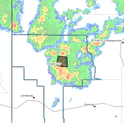 FLOOD ADVISORY IN EFFECT UNTIL 515 PM MDT THIS AFTERNOON...
* WHAT...Flooding caused by excessive rainfall is expected.
* WHERE...A portion of southwest New Mexico, including the following
county, Grant.
* WHEN...Until 515 PM MDT.
* IMPACTS...Minor flooding in low-lying and poor drainage areas.
Some low-water crossings may become impassable. Ponding of water
in urban or other areas is occurring or is imminent.
* ADDITIONAL DETAILS...
- At 313 PM MDT, Doppler radar indicated heavy rain due to
thunderstorms. Minor flooding is ongoing or expected to begin
shortly in the advisory area. Between 0.5 and 1 inch of rain
has fallen.
- Additional rainfall of up to 0.5 inches is expected over the
area. This additional rain will result in minor flooding.
Page 2 of 185


WARNING: All articles and photos with a byline or photo credit are copyrighted to the author or photographer. You may not use any information found within the articles without asking permission AND giving attribution to the source. Photos can be requested and may incur a nominal fee for use personally or commercially.
Disclaimer: If you find errors in articles not written by the Beat team but sent to us from other content providers, please contact the writer, not the Beat. For example, obituaries are always provided by the funeral home or a family member. We can fix errors, but please give details on where the error is so we can find it. News releases from government and non-profit entities are posted generally without change, except for legal notices, which incur a small charge.
NOTE: If an article does not have a byline, it was written by someone not affiliated with the Beat and then sent to the Beat for posting.
Images: We have received complaints about large images blocking parts of other articles. If you encounter this problem, click on the title of the article you want to read and it will take you to that article's page, which shows only that article without any intruders.
New Columnists: The Beat continues to bring you new columnists. And check out the old faithfuls who continue to provide content.
Newsletter: If you opt in to the Join GCB Three Times Weekly Updates option above this to the right, you will be subscribed to email notifications with links to recently posted articles.
It has come to this editor's attention that people are sending information to the Grant County Beat Facebook page. Please be aware that the editor does not regularly monitor the page. If you have items you want to send to the editor, please send them to editor@grantcountybeat.com. Thanks!
Here for YOU: Consider the Beat your DAILY newspaper for up-to-date information about Grant County. It's at your fingertips! One Click to Local News. Thanks for your support for and your readership of Grant County's online news source—www.grantcountybeat.com
Feel free to notify editor@grantcountybeat.com if you notice any technical problems on the site. Your convenience is my desire for the Beat. The Beat totally appreciates its readers and subscribers!
Compliance: Because you are an esteemed member of The Grant County Beat readership, be assured that we at the Beat continue to do everything we can to be in full compliance with GDPR and pertinent US law, so that the information you have chosen to give to us cannot be compromised.
Those new to providing news releases to the Beat are asked to please check out submission guidelines at https://www.grantcountybeat.com/about/submissions. They are for your information to make life easier on the readers, as well as for the editor.
Advertising: Don't forget to tell advertisers that you saw their ads on the Beat.
Classifieds: We have changed Classifieds to a simpler option. Check periodically to see if any new ones have popped up. Send your information to editor@grantcountybeat.com and we will post it as soon as we can. Instructions and prices are on the page.