 CRITICAL FIRE WEATHER CONDITIONS FOR SOUTHERN NEW MEXICO ON SATURDAY AND SUNDAY... .Upper level ridge will flatten on Saturday and Sunday as an upper level trough races across the Northern Rockies. As a result, the mid to upper level pressure gradient will tighten across the region, orientated from SW to NE inducing SWerly flow aloft. This will ultimately promote daily afternoon/evening occurrences of lee-side low development over the Front Range and sufficient surface troughing across New Mexico. Thus, increasing surface and low-level winds across the area. This coupled with very low Minimum RH values and dry fuels will promote Critical Fire Weather conditions this weekend.
Southwest Mountains/Gila NF/Apache NF/GLZ-
Southwest Deserts and Lowlands/Las Cruces BLM/GLZ-
347 AM MDT Fri Apr 11 2025
...RED FLAG WARNING IN EFFECT FROM NOON TO 9 PM MDT SATURDAY FOR
BREEZY WINDS, DRY FUELS, AND LOW RELATIVE HUMIDITY FOR
SOUTHWESTERN NEW MEXICO...
...FIRE WEATHER WATCH REMAINS IN EFFECT FROM SUNDAY AFTERNOON
THROUGH SUNDAY EVENING FOR BREEZY WINDS, DRY FUELS, AND LOW
RELATIVE HUMIDITY FOR SOUTHWESTERN NEW MEXICO...
The National Weather Service in El Paso Tx/Santa Teresa has
issued a Red Flag Warning for portions of southwestern New Mexico,
which is in effect from noon to 9 PM MDT Saturday. A Fire Weather
Watch remains in effect for southwestern New Mexico on Sunday.
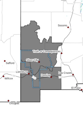
* AFFECTED AREA...Fire Weather Zone 110 Southwest Mountains/Gila
NF/Apache NF/GLZ and Fire Weather Zone 111 Southwest Deserts
and Lowlands/Las Cruces BLM/GLZ.
* TIMING...For the Warning, in effect from 12 PM to 9PM on
Saturday. For the Watch, in effect from 12 PM to 9 PM on Sunday.
* WINDS...West 15 to 25 mph with gusts up to 30 to 40 mph both
afternoons.
* RELATIVE HUMIDITY...4 to 10 percent each afternoon, with poor
overnight recoveries Saturday night and Sunday morning.
* EXPIREMENTAL RFTI...4 to 5 or Near-Critical to Critical on
Saturday. 4 to 6 or Near-Critical to Critical on Sunday.
* IMPACTS...Any fires that develop will likely spread rapidly.
Outdoor burning is not recommended.
PRECAUTIONARY/PREPAREDNESS ACTIONS...
A Red Flag Warning means that critical fire weather conditions
are either occurring now, or will shortly. A combination of
strong winds, low relative humidity, and warm temperatures can
contribute to extreme fire behavior.
A Fire Weather Watch means that critical fire weather conditions
are forecast to occur. Listen for later forecasts and possible
Red Flag Warnings.