


 CRITICAL TO EXTREME FIRE WEATHER FOR SOUTHERN NEW MEXICO AND FAR WEST TEXAS ON WEDNESDAY AND THURSDAY... .An upper level trough is expected to swing through the Four Corners on Thursday aligning the jet stream across much of New Mexico. This will develop a lee cyclone over Eastern Colorado while deep mixing taps into higher winds aloft. Windy to very windy conditions will combine with single-digit lowland minimum RH values with only the highest elevations seeing minimum RH values in the teens. When combined with very dry fuels, critical to possibly extreme fire weather conditions are expected for Thursday afternoon.
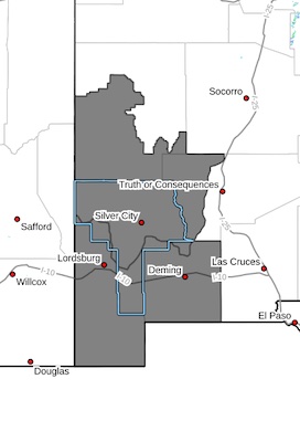
Southwest Mountains/Gila NF/Apache NF/GLZ-
Southwest Deserts and Lowlands/Las Cruces BLM/GLZ-
205 PM MDT Tue Apr 15 2025
...RED FLAG WARNING IN EFFECT FROM NOON TO 8 PM MDT WEDNESDAY FOR
BREEZY WINDS, LOW HUMIDITY, AND CRITICALLY DRY FUELS FOR
SOUTHWESTERN NEW MEXICO...
...RED FLAG WARNING IN EFFECT FROM 10 AM TO 9 PM MDT THURSDAY FOR
STRONG WINDS, VERY LOW HUMIDITY, AND DRY FUELS FOR SOUTHWESTERN
NEW MEXICO...
* AFFECTED AREA...Fire Weather Zone 110 Southwest Mountains/Gila
NF/Apache NF/GLZ and Fire Weather Zone 111 Southwest Deserts
and Lowlands/Las Cruces BLM/GLZ.
* TIMING...From 12 PM MDT to 8 PM MDT on Wednesday. From 10 AM MDT
to 9 PM MDT on Thursday.
* WIND...Southwest 20 to 25 mph with gusts up to 40 mph on
Wednesday. Southwest 25 to 35 with gusts up to 55 to 65 mph on
Thursday.
* RELATIVE HUMIDITY...As low as 4 to 7 percent both days.
* EXPERIMENTAL RFTI...4 to 6 or Critical on Wednesday. 5 to 9 or
Critical to Extreme on Thursday.
* IMPACTS...any fires that develop will likely spread rapidly.
Outdoor burning is not recommended.
PRECAUTIONARY/PREPAREDNESS ACTIONS...
A Red Flag Warning means that critical fire weather conditions
are either occurring now, or will shortly. A combination of
strong winds, low relative humidity, and warm temperatures can
contribute to extreme fire behavior.


