

 Click to Search
Search
{{#data.error.root_cause}}
{{/data.error}}
{{^data.error}}
[{{{type}}}] {{{reason}}}
{{/data.error.root_cause}}
{{#data.hits.hits}}
{{#_source.featured}}
FEATURED
{{/_source.featured}}
{{#_source.showImage}}
{{#_source.image}}
 {{/_source.image}}
{{/_source.showImage}}
{{/_source.image}}
{{/_source.showImage}}
{{/data.hits.hits}}
{{{_source.title}}} {{#_source.showPrice}} {{{_source.displayPrice}}} {{/_source.showPrice}}
{{#_source.showLink}} {{/_source.showLink}} {{#_source.showDate}}{{{_source.displayDate}}}
{{/_source.showDate}}{{{_source.description}}}
{{#_source.additionalInfo}}{{#_source.additionalFields}} {{#title}} {{{label}}}: {{{title}}} {{/title}} {{/_source.additionalFields}}
{{/_source.additionalInfo}}

Latest News


Subscribe to the Update
- Category: Weather
 CRITICAL FIRE CONDITIONS SATURDAY AND SUNDAY ACROSS SOUTHWEST, SOUTH CENTRAL NEW MEXICO AND FAR WEST TEXAS... High pressure nudging in from the west is causing temperatures to be well above seasonal averages, and relative humidity to be critically low. Daily highs this weekend will average over 10 degrees above normal, as relative humidity drops into the low teens and single-digits both days, with very poor overnight recovery. A two-day trough passage to our north will add increased winds mid afternoon on Saturday, which will continue and further strengthen overnight into Sunday. These winds combined with single digit RH's, warm temperatures, and drying fuels will lead to critical fire weather conditions.
123 PM MDT Fri Mar 13 2026
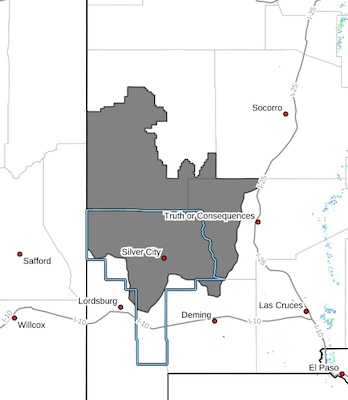
...RED FLAG WARNING IN EFFECT FROM 3 PM TO 10 PM MDT SATURDAY FOR CRITICAL FIRE WEATHER CONDITIONS FOR THE GILA REGION AND BLACK
RANGE...
...FIRE WEATHER WATCH NOW IN EFFECT SUNDAY AFTERNOON FOR
GUSTY WINDS AND VERY LOW RELATIVE HUMIDITY FOR PARTS OF SOUTH CENTRAL AND SOUTHWEST NEW MEXICO AND FAR WEST TEXAS...
- Category: Front Page News
News
from the Fire Adapted New Mexico Learning Network

Excerpts:
Wildfire Wednesday #179: Red Flag Warnings, Fire Restrictions, and Burn Bans Explained
- Category: Weather
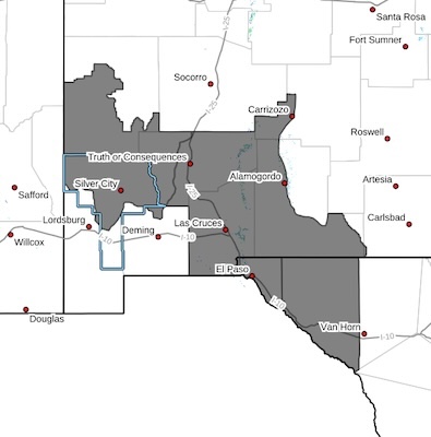 CRITICAL FIRE CONDITIONS POSSIBLE SATURDAY AND SUNDAY... Gusty winds and very low relative humidities are expected for Saturday ahead of a strong upper level trough moving into the Rockies. West to southwest winds of 15-25 mph with gusts over 35 mph are possible in the Sacramento Mountains. These winds combined with single digit RH's and drying fuels will lead to critical fire weather conditions. A second day of gusty winds is expected on Sunday with winds of 15-25 mph, overspreading all of South Central and Southwestern NM, which will combine with very low relative humidities to create critical fire weather conditions. ERCs are relatively higher across the Gila National Forest, but with recent beetle die-off, the Gila is included within the Fire Weather Watch for Sunday.
Southwest Mountains/Gila NF/Apache NF/GLZ-
South Central Lowlands and Southern Rio Grande Valley/BLM/GLZ-
Texas Fire Weather Zone 055 El Paso County- Texas Fire Weather Zone 056 Hudspeth County-331 AM MDT Fri Mar 13 2026
- Category: Front Page News
On Friday March 6, 2026 at approximately 1:52 PM Deputies with the Grant County Sheriff's Office responded to the 100 block of Arenas Valley Road in reference to a structure fire. A male decedent was discovered inside the home.
The Grant County Sheriff's Office and Office of Medical Investigator conducted an investigation to positively identify the decedent and to discover the cause of death. The decedent has been positively identified and confirmed to be Henry A. Wedgewood of Arenas Valley. An official cause of death has not yet been determined and is still under investigation.
The investigation is ongoing and information will be released as it becomes available.
- Category: Front Page News
On the early morning hours of March 6, 2026 a male pedestrian was hit by a vehicle and left alone on US Highway 180 between Bayard and Hurley. A press release for information has been previously released but the Grant County Sheriff's Office is continuing to request information regarding the identification of anyone involved.
Debris was recovered that indicated that the vehicle that struck the pedestrian was likely a Ford Truck or SUV. It is believed that the vehicle sustained damage to either the driver or passenger side due to the recovery of a side mirror. The vehicle is believed to be in the range of a 2004-2008 (11th Generation Ford). No other vehicle information is available for disclosure at this time. The vehicle and driver have yet to be identified. Any information regarding who could be responsible is again requested.
- Category: Front Page News
By Roger Lanse
On Wednesday, Mar. 11, 2026, at about 7:55 a.m., Santa Clara Police Department Chief Lonnie Sandoval was made aware by the Santa Clara Post Office Postmistress of smoke and a fire alarm at the post office. According to Chief Sandoval, camera footage showed John Elizalde, 46, of Santa Clara, entering the post office at 2 a.m. earlier that morning. Chief Sandoval said Elizalde was known to him due to prior incidents.
Camera footage showed Elizalde walking in and out of the building and then walking back in, removing the lid from a trash can, and propping it up in front of a window to hide what he was doing, Chief Sandoval stated. Elizalde could then be seen throwing something in the trash can and the glow of a fire and smoke could be seen. Elizalde then left the building smiling at the camera.
Page 6 of 151


Content on the Beat
WARNING: All articles and photos with a byline or photo credit are copyrighted to the author or photographer. You may not use any information found within the articles without asking permission AND giving attribution to the source. Photos can be requested and may incur a nominal fee for use personally or commercially.
Disclaimer: If you find errors in articles not written by the Beat team but sent to us from other content providers, please contact the writer, not the Beat. For example, obituaries are always provided by the funeral home or a family member. We can fix errors, but please give details on where the error is so we can find it. News releases from government and non-profit entities are posted generally without change, except for legal notices, which incur a small charge.
NOTE: If an article does not have a byline, it was written by someone not affiliated with the Beat and then sent to the Beat for posting.
Images: We have received complaints about large images blocking parts of other articles. If you encounter this problem, click on the title of the article you want to read and it will take you to that article's page, which shows only that article without any intruders.
New Columnists: The Beat continues to bring you new columnists. And check out the old faithfuls who continue to provide content.
Newsletter: If you opt in to the Join GCB Three Times Weekly Updates option above this to the right, you will be subscribed to email notifications with links to recently posted articles.
Editor's Notes
It has come to this editor's attention that people are sending information to the Grant County Beat Facebook page. Please be aware that the editor does not regularly monitor the page. If you have items you want to send to the editor, please send them to editor@grantcountybeat.com. Thanks!
Here for YOU: Consider the Beat your DAILY newspaper for up-to-date information about Grant County. It's at your fingertips! One Click to Local News. Thanks for your support for and your readership of Grant County's online news source—www.grantcountybeat.com
Feel free to notify editor@grantcountybeat.com if you notice any technical problems on the site. Your convenience is my desire for the Beat. The Beat totally appreciates its readers and subscribers!
Compliance: Because you are an esteemed member of The Grant County Beat readership, be assured that we at the Beat continue to do everything we can to be in full compliance with GDPR and pertinent US law, so that the information you have chosen to give to us cannot be compromised.
Submitting to the Beat
Those new to providing news releases to the Beat are asked to please check out submission guidelines at https://www.grantcountybeat.com/about/submissions. They are for your information to make life easier on the readers, as well as for the editor.
Advertising: Don't forget to tell advertisers that you saw their ads on the Beat.
Classifieds: We have changed Classifieds to a simpler option. Check periodically to see if any new ones have popped up. Send your information to editor@grantcountybeat.com and we will post it as soon as we can. Instructions and prices are on the page.