


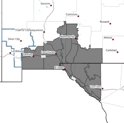
 Southwest Desert/Mimbres Basin-Northern Dona Ana County-Southern
Dona Ana County/Mesilla Valley-Otero Mesa-West Central Tularosa
Basin/White Sands-East Central Tularosa Basin/Alamogordo-
Southeast Tularosa Basin-Western El Paso County-Eastern/Central
El Paso County-Northern Hudspeth Highlands/Hueco Mountains-Salt
Basin-Southern Hudspeth Highlands-Rio Grande Valley of Eastern El
Paso/Western Hudspeth Counties-Rio Grande Valley of Eastern
Hudspeth County-
Including the cities of Salt Flat, Radium Springs, Sierra Blanca,
Tularosa, White Sands National Park, Chaparral, White Sands Range Headquarters, Las Cruces,
East and Northeast El Paso, Hueco
Tanks, Crow Flats, Holloman AFB, Deming, Cornudas, Loma Linda,
Fort Hancock, Orogrande, Fabens, Vado, Alamogordo, Columbus, West
El Paso, Indian Hot Springs, Garfield, Dell City, Tornillo,
Socorro, Sunland Park, Upper Valley, Fort Bliss, Downtown El
Paso, and Hatch
1059 AM MDT Fri Mar 14 2025
...BLOWING DUST ADVISORY IN EFFECT UNTIL 8 PM MDT THIS EVENING...
* WHAT...Visibility between one-quarter and one mile in blowing dust
expected.
* WHERE...Portions of south central and southwest New Mexico and
southwest Texas.
* WHEN...Until 8 PM MDT this evening.
* IMPACTS...Hazardous driving conditions due to reduced visibility.
PRECAUTIONARY/PREPAREDNESS ACTIONS...
Persons with respiratory problems should make preparations to stay
indoors until the storm passes. Be ready for a sudden drop in
visibility to near zero. If you encounter blowing dust or blowing
sand on the roadway or see it approaching, pull off the road as far
as possible and put your vehicle in park. Turn the lights all the
way off and keep foot off the brake pedal. Remember, 'Pull Aside,
Stay Alive'.


