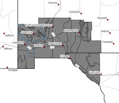
 Upper Gila River Valley-Southern Gila Foothills/Mimbres Valley-
Southwest Desert/Lower Gila River Valley-Lowlands of the Bootheel-
Uplands of the Bootheel-Southwest Desert/Mimbres Basin-
Eastern Black Range Foothills-Sierra County Lakes-
Northern Dona Ana County-Southern Dona Ana County/Mesilla Valley-
West Slopes Sacramento Mountains Below 7500 Feet-
Sacramento Mountains Above 7500 Feet-
East Slopes Sacramento Mountains Below 7500 Feet-Otero Mesa-
Central Grant County/Silver City Area-
Southern Gila Region Highlands/Black Range-
West Central Tularosa Basin/White Sands-
East Central Tularosa Basin/Alamogordo-Southeast Tularosa Basin-
Western El Paso County-Eastern/Central El Paso County-
Northern Hudspeth Highlands/Hueco Mountains-Salt Basin-
Southern Hudspeth Highlands-
Rio Grande Valley of Eastern El Paso/Western Hudspeth Counties-
Rio Grande Valley of Eastern Hudspeth County-
Including the cities of Cliff, Buckhorn, Gila Hot Springs,
Mule Creek, Hurley, Faywood, Grant County Airport, Lordsburg,
Red Rock, Virden, Antelope Wells, Animas, Hachita, Cloverdale,
Deming, Columbus, Hillsboro, Winston, Truth Or Consequences,
Derry, Spaceport, Garfield, Hatch, Radium Springs, Las Cruces,
Vado, Sunland Park, Mescalero, Timberon, Mountain Park,
Cloudcroft, Sunspot, Apache Summit, Mayhill, Pinon, Sacramento,
Crow Flats, Silver City, Mimbres, Fort Bayard, Lake Roberts,
Kingston, White Sands National Park, Chaparral,
White Sands Range Headquarters, Alamogordo, Tularosa,
Holloman AFB, Orogrande, Downtown El Paso, West El Paso,
Upper Valley, East and Northeast El Paso, Socorro, Fort Bliss,
Hueco Tanks, Loma Linda, Cornudas, Dell City, Salt Flat,
Sierra Blanca, Fabens, Fort Hancock, Tornillo,
and Indian Hot Springs
135 AM MST Sun Jan 5 2025
...SIGNIFICANT COLD AND SNOW CHANCES WEDNESDAY THROUGH FRIDAY...
Today marks the beginning of a cooling trend as a series of cold
fronts arrive to southern New Mexico and Far West Texas. The most
significant of these cold fronts is set to arrive early Wednesday
morning. Temperatures will be well into the 20s by Wednesday
morning, which will combine with breezy easterly winds to create
wind chill values in the single digits and teens with below zero
values in the mountains. Highs will struggle to get above freezing
Wednesday afternoon, especially east of the Rio Grande. The cold
will be slow to leave with lows well into the teens continuing
each morning through Saturday although winds will not be as
strong. Remember to protect the four P's: people, pets, plants,
and pipes.
In addition to the significant cold, an upper-level storm system
will slowly swing through the region, bringing with it a low to
moderate chance for snow beginning Wednesday, lasting into Friday
morning. Early indications are snow totals will generally be light
with lowlands expecting 1-2" and mountains receiving 2-4".
However, the exact track of this storm is still uncertain and
there is a good chance these totals will change.
It is important to monitor the forecast over the next few days
while making preparations for the cold and snow.


