


 BULLETIN - EAS ACTIVATION REQUESTED
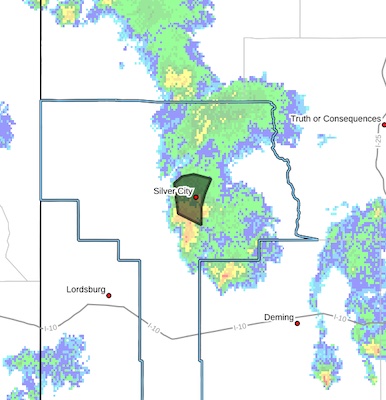
Flash Flood Warning
National Weather Service El Paso Tx/Santa Teresa NM
621 PM MDT Sun Jul 28 2024
The National Weather Service in El Paso Tx/Santa Teresa has issued a
* Flash Flood Warning for...
Central Grant in southwestern New Mexico...
* Until 815 PM MDT.
* At 621 PM MDT, Doppler radar indicated thunderstorms producing
heavy rain across the warned area. Between 0.5 and 1 inch of rain
has fallen. Additional rainfall amounts of 0.5 to 1 inch are
possible in the warned area. Flash flooding is ongoing or expected
to begin shortly.
HAZARD...Flash flooding caused by thunderstorms.
SOURCE...Radar.
IMPACT...Flash flooding of small creeks and streams, urban
areas, highways, streets and underpasses as well as
other poor drainage and low-lying areas.
* Some locations that will experience flash flooding include...
Silver City.
PRECAUTIONARY/PREPAREDNESS ACTIONS...
Turn around, don't drown when encountering flooded roads. Most flood
deaths occur in vehicles.
Be aware of your surroundings and do not drive on flooded roads.
In hilly terrain there are numerous low water crossings which are
potentially dangerous in heavy rain. Do not attempt to cross flooded
roads. Find an alternate route.


