


 Flash Flood Warning
National Weather Service El Paso Tx/Santa Teresa NM
721 PM MDT Thu Jul 31 2025
The National Weather Service in El Paso Tx/Santa Teresa has issued a
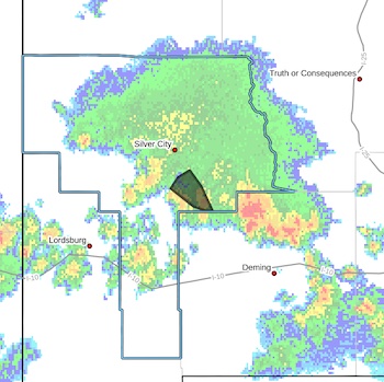
* Flash Flood Warning for...
Central Grant County in southwestern New Mexico...
* Until 915 PM MDT.
* At 721 PM MDT, Doppler radar indicated thunderstorms producing heavy rain across the warned area. Between 1 and 2 inches of rain have fallen. Additional rainfall amounts up to 1 inch are possible
in the warned area. Flash flooding is ongoing or expected to begin shortly.
HAZARD...Flash flooding caused by thunderstorms.
SOURCE...Radar.
IMPACT...Flash flooding of small creeks and streams, urban
areas, highways, streets and underpasses as well as
other poor drainage and low-lying areas.
* Some locations that will experience flash flooding include...
mainly rural areas of Central Grant County
PRECAUTIONARY/PREPAREDNESS ACTIONS...
Turn around, don't drown when encountering flooded roads. Most flood
deaths occur in vehicles.
Be especially cautious at night when it is harder to recognize the
dangers of flooding.
Remain alert for flooding even in locations not receiving rain.
Arroyos, streams, and rivers can become raging killer currents in a
matter of minutes, even from distant rainfall.


