


 National Weather Service El Paso Tx/Santa Teresa NM
326 PM MDT Wed Aug 13 2025
The National Weather Service in El Paso Tx/Santa Teresa has issued a
* Flash Flood Warning for...
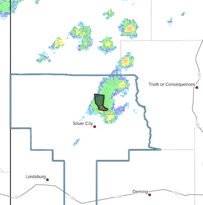
The Trout Fire Burn Scar in...
Northeastern Grant County in southwestern New Mexico...
* Until 530 PM MDT.
* At 326 PM MDT, Doppler radar indicated thunderstorms producing heavy rain over the Trout Fire Burn Scar. Between 1 and 1.5 inches
of rain have fallen. Flash flooding is ongoing or expected to begin shortly.
Excessive rainfall over the burn scar will result in increased flow
moving through the Trout Fire Burn Scar, into canyons flowing north
towards Sapillo Creek BELOW Lake Roberts Dam, including Meadow
Creek. Sapillo Creek DOWNSTREAM...or WEST of Lake Roberts Dam will
also be impacted.
HAZARD...Flash flooding caused by thunderstorms in and around
the Trout Fire Burn Scar.
SOURCE...Radar.
IMPACT...Flooding of areas in and around the Trout Fire Burn
Scar.
* Some locations that will experience flash flooding include...
Meadow Creek, Trout Valley and Sapillo Creek Valley.
This includes the following streams and drainages...
Bear Creek, Meadow Creek, Copperas Creek, Trout Creek, Mimbres
River and Sapillo Creek.
PRECAUTIONARY/PREPAREDNESS ACTIONS...
In hilly terrain there are numerous low water crossings which are
potentially dangerous in heavy rain. Do not attempt to cross flooded
roads. Find an alternate route.


