


 Flash Flood Warning
National Weather Service El Paso Tx/Santa Teresa NM
542 PM MDT Tue Jun 24 2025
The National Weather Service in El Paso Tx/Santa Teresa has issued a
* Flash Flood Warning for...
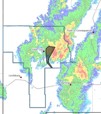
Central Grant County in southwestern New Mexico...
Luna County in southwestern New Mexico...
* Until 745 PM MDT.
* At 542 PM MDT, Doppler radar indicated thunderstorms producing
heavy rain across the warned area. Between 1.5 and 2 inches of
rain have fallen across Arenas Valley. Additional rainfall amounts of 0.5 to 1.5 inches are possible in the warned area. Flash flooding is ongoing or expected to begin shortly.
HAZARD...Flash flooding caused by thunderstorms.
SOURCE...Radar.
IMPACT...Flash flooding of arroyos, urban areas, highways,
streets and underpasses as well as other poor drainage
and low-lying areas.
* Some locations that will experience flash flooding include...
Hurley, Silver City, Bayard, Cobre, North Hurley, Hanover, Fierro,
Santa Clara, Fort Bayard and Arenas Valley.
Low Water Crossings along Cameron Creek, located west of U.S.
Highway 180 and south of Santa Clara will likely become inundated.
PRECAUTIONARY/PREPAREDNESS ACTIONS...
Turn around, don't drown when encountering flooded roads. Most flood
deaths occur in vehicles.
Remain alert for flooding even in locations not receiving rain.
Arroyos, streams, and rivers can become raging killer currents in a
matter of minutes, even from distant rainfall.


