


 BULLETIN - EAS ACTIVATION REQUESTED
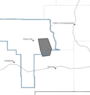
Flash Flood Warning
National Weather Service El Paso Tx/Santa Teresa NM
823 PM MDT Sun Jun 30 2024
The National Weather Service in El Paso Tx/Santa Teresa has issued a
* Flash Flood Warning for...
East Central Grant in southwestern New Mexico...
North Central Luna in southwestern New Mexico...
* Until 1015 PM MDT.
* At 823 PM MDT, Doppler radar indicated thunderstorms producing
heavy rain across the warned area. Up to 2 inches of rain have
fallen. Additional rainfall amounts up to 1 inch are possible in
the warned area. Flash flooding is ongoing or expected to begin
shortly.
HAZARD...Flash flooding caused by thunderstorms.
SOURCE...Radar.
IMPACT...Flash flooding of small creeks and streams, urban
areas, highways, streets and underpasses as well as
other poor drainage and low-lying areas.
* Some locations that will experience flash flooding include...
Faywood, San Lorenzo, Sherman, Cobre, Bayard, San Juan and Hanover.
PRECAUTIONARY/PREPAREDNESS ACTIONS...
Turn around, don't drown when encountering flooded roads. Most flood
deaths occur in vehicles.
Be especially cautious at night when it is harder to recognize the
dangers of flooding.
LAT...LON 3282 10813 3283 10791 3263 10782 3250 10786
3248 10803 3260 10808
FLASH FLOOD...RADAR INDICATED


