


 FLASH FLOOED WARNINGIN EFFECT UNTIL 900 PM MDT THIS EVENING...
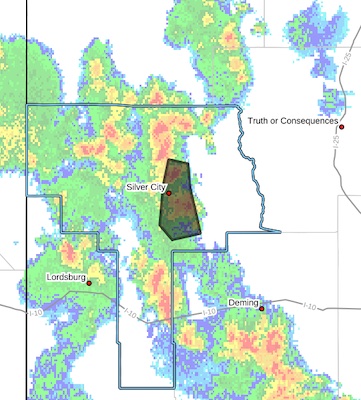
* WHAT...Flooding caused by excessive rainfall is expected.
* WHERE...A portion of southwest New Mexico, including the following
county, Grant.
* WHEN...Until 830 PM MDT.
* IMPACTS...Minor flooding in low-lying and poor drainage areas.
River or stream flows are elevated.
* ADDITIONAL DETAILS...
- At 634 PM MDT, Doppler radar indicated heavy rain due to
thunderstorms. Minor flooding is ongoing or expected to begin
shortly in the advisory area. Up to 1 inch of rain has
fallen.
- Additional rainfall of up to 1 inch is expected over the
area. This additional rain will result in minor flooding.
- Some locations that may experience flooding include...
Silver City, Hurley, Bayard, Pinos Altos, North Hurley, Santa
Clara, Fort Bayard and Arenas Valley.
- http://www.weather.gov/safety/flood
PRECAUTIONARY/PREPAREDNESS ACTIONS...
Turn around, don't drown when encountering flooded roads. Most flood
deaths occur in vehicles.
Flooding is occurring or is imminent. It is important to know where
you are relative to streams, rivers, or creeks which can become
killers in heavy rains. Campers and hikers should avoid streams or
creeks.


