


 Flash Flood Warning
National Weather Service El Paso Tx/Santa Teresa NM
247 PM MDT Sun Aug 31 2025
The National Weather Service in El Paso Tx/Santa Teresa has issued a
* Flash Flood Warning for...
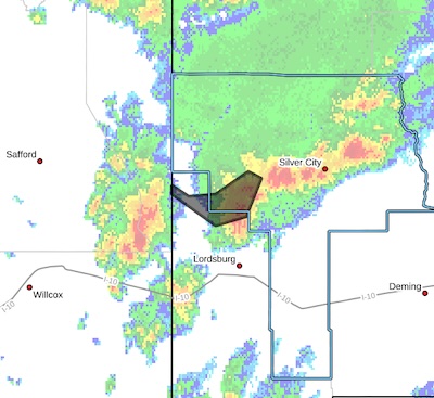
Western Grant County in southwestern New Mexico...
Northwestern Hidalgo County in southwestern New Mexico...
* Until 545 PM MDT.
* At 247 PM MDT, Doppler radar indicated thunderstorms producing heavy rain across the warned area. Between 1.5 and 2 inches of rain have fallen. Flash flooding is ongoing or expected to begin shortly.
HAZARD...Flash flooding caused by thunderstorms.
SOURCE...Radar.
IMPACT...Flash flooding of small creeks and streams, urban
areas, highways, streets and underpasses as well as
other poor drainage and low-lying areas.
* Some locations that will experience flash flooding include...
Redrock, Virden, Gila Lower Box and Gila Middle Box.
This includes the following streams and drainages...
Ash Creek, Gila River and Blue Creek.
PRECAUTIONARY/PREPAREDNESS ACTIONS...
Remain alert for flooding even in locations not receiving rain.
Arroyos, streams, and rivers can become raging killer currents in a
matter of minutes, even from distant rainfall.
Flooding is occurring or is imminent. It is important to know where
you are relative to streams, rivers, or creeks which can become
killers in heavy rains. Campers and hikers should avoid streams or
creeks.
FLASH FLOOD...RADAR INDICATED


