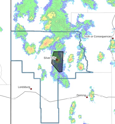
 FLOOD ADVISORY IN EFFECT UNTIL 645 PM MDT THIS EVENING...
* WHAT...Flooding caused by excessive rainfall is expected.
* WHERE...A portion of southwest New Mexico, including the following
county, Grant.
* WHEN...Until 645 PM MDT.
* IMPACTS...Minor flooding in low-lying and poor drainage areas.
Rises in small streams and normally dry arroyos. Water over
roadways.
* ADDITIONAL DETAILS...
- At 450 PM MDT, Doppler radar indicated heavy rain due to
thunderstorms. Minor flooding is ongoing or expected to begin
shortly in the advisory area. Between 0.5 and 1 inch of rain
has fallen.
- Additional rainfall of up to 0.5 to 1 inch is expected over
the area. This additional rain will result in minor flooding.
- Some locations that may experience flooding include...
Silver City, Tyrone, Pinos Altos, Santa Clara, Fort Bayard
and Arenas Valley.
- http://www.weather.gov/safety/flood
PRECAUTIONARY/PREPAREDNESS ACTIONS...
Turn around, don't drown when encountering flooded roads. Most flood
deaths occur in vehicles.
Be aware of your surroundings and do not drive on flooded roads.


