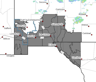
 Upper Gila River Valley-Southwest Desert/Lower Gila River Valley-
Lowlands of the Bootheel-Uplands of the Bootheel-Southwest
Desert/Mimbres Basin-Sierra County Lakes-Northern Dona Ana County-
Southern Dona Ana County/Mesilla Valley-Otero Mesa-West Central
Tularosa Basin/White Sands-East Central Tularosa Basin/Alamogordo-
Southeast Tularosa Basin-Western El Paso County-Eastern/Central
El Paso County-Northern Hudspeth Highlands/Hueco Mountains-Salt
Basin-Southern Hudspeth Highlands-Rio Grande Valley of Eastern El
Paso/Western Hudspeth Counties-Rio Grande Valley of Eastern
Hudspeth County-
Including the cities of Hueco Tanks, Tularosa, East and Northeast
El Paso, Derry, Socorro, Deming, Dell City, Animas, West El Paso,
Chaparral, Hachita, Truth Or Consequences, Salt Flat, Fort
Hancock, Sunland Park, Las Cruces, Orogrande, Holloman AFB, Fort
Bliss, Spaceport, Hatch, Lordsburg, Crow Flats, Fabens, Vado,
Alamogordo, Cloverdale, Sierra Blanca, Indian Hot Springs, Loma
Linda, Downtown El Paso, Radium Springs, Cornudas, Red Rock,
Tornillo, White Sands National Park, Columbus, Cliff, Gila Hot
Springs, Garfield, White Sands Range Headquarters, Upper Valley,
Antelope Wells, Mule Creek, Buckhorn, and Virden
905 AM MDT Mon Jun 10 2024
...EXCESSIVE HEAT WATCH IN EFFECT FROM WEDNESDAY AFTERNOON THROUGH
6 a.m. Saturday morning...
* WHAT...Dangerously hot conditions with high temperatures of
105-110.
* WHERE...Portions of south central and southwest New Mexico and
southwest Texas.
* WHEN...From Wednesday afternoon through early Saturday morning.
* IMPACTS...Heat related illnesses increase significantly during
extreme heat events.
PRECAUTIONARY/PREPAREDNESS ACTIONS...
Drink plenty of fluids, stay in an air-conditioned room, stay out of
the sun, and check up on relatives and neighbors.
Do not leave young children and pets in unattended vehicles. Car
interiors will reach lethal temperatures in a matter of minutes.
Monitor the latest forecasts and warnings for updates.HighÂ


