


 CRITICAL FIRE WEATHER CONDITIONS ON TUESDAY... .Strong southwest flow ahead of an approaching upper low will increase winds Tuesday afternoon in conjunction with very dry conditions. Single-digit relative humidity will exist for several hours in southern New Mexico and far west Texas. Winds will peak during the mid-afternoon hours, with gusts up to 40 mph. Moisture content remains low despite light precipitation last Saturday, ERC values are well above average for early March. Fire danger will be critical due to these weather conditions.
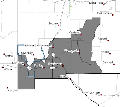
...RED FLAG WARNING IN EFFECT FROM TUESDAY AFTERNOON AND EVENING
FOR DRY FUELS, LOW HUMIDITY, AND BREEZY WINDS
The National Weather Service in El Paso Tx/Santa Teresa has
issued a Red Flag Warning for portions of southwest and south-
central New Mexico, which is in effect from noon to 8 PM MDT
Tuesday. The Fire Weather Watch is no longer in effect.
* AFFECTED AREA...Fire Weather Zone 111 Southwest Deserts and
Lowlands/Las Cruces BLM/GLZ, Fire Weather Zone 112 South
Central Lowlands and Southern Rio Grande Valley/BLM/GLZ and
Fire Weather Zone 113 Capitan and Sacramento Mountains/Lincoln
NF/LNZ.
* TIMING...12 PM to 8 PM
* WIND...Southwest 15 to 25 mph with gusts up to 40 mph.
* RELATIVE HUMIDITY...7 to 15 percent.
* EXPERIMENTAL RFTI...3 to 5 or Near Critical to Critical
* IMPACTS...any fires that develop will likely spread rapidly.
Outdoor burning is not recommended.
PRECAUTIONARY/PREPAREDNESS ACTIONS...
A Red Flag Warning means that critical fire weather conditions
are either occurring now, or will shortly. A combination of
strong winds, low relative humidity, and warm temperatures can
contribute to extreme fire behavior.


