


CRITICAL FIRE CONDITIONS FOR SOUTHERN NEW MEXICO AND WEST TEXAS ON TUESDAY... .Strong jet stream flow aloft crossing the Southern Rockies will induce a deep 980-mb surface low over the Central Plains on Tuesday. Strong west-southwest winds across New Mexico and west Texas are expected during the afternoon and evening hours with sustained 20-ft speeds 25 to 35 mph and gusts as high as 60 mph. Relative 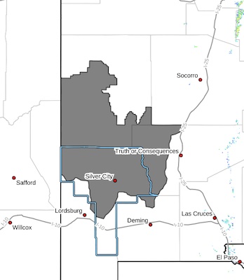 humidity continues to be dry, falling below 15% in the desert lowlands and 15 to 25% in the National Forests. Mountain zones are included in the warning given unseasonably dry fuels and ongoing severe drought conditions. Latest ERCs are near the 90th- percentile. Any fires that start have the potential to spread rapidly.
...RED FLAG WARNING IN EFFECT FROM NOON TO 9 PM MDT TUESDAY FOR
STRONG WINDS, DRY FUELS, AND LOW RELATIVE HUMIDITY FOR SOUTHERN
NEW MEXICO AND FAR WEST TEXAS...
* AFFECTED AREA...Fire Weather Zone 110 Southwest Mountains/Gila
NF/Apache NF/GLZ.
* TIMING...Tuesday afternoon Noon through 9 PM MDT.
* WINDS...West 25 to 35 mph with gusts up to 60 mph.
* RELATIVE HUMIDITY...15 to 20 percent.
* EXPERIMENTAL RFTI...4 to 5 or Near-Critical to Critical
* IMPACTS...Any fires that develop will likely spread rapidly.
Outdoor burning is not recommended.
PRECAUTIONARY/PREPAREDNESS ACTIONS...
A Red Flag Warning means that critical fire weather conditions
are either occurring now, or will shortly. A combination of
strong winds, low relative humidity, and warm temperatures can
contribute to extreme fire behavior.


