

 Click to Search
Search
[{{{type}}}] {{{reason}}}
{{/data.error.root_cause}}
{{{_source.title}}} {{#_source.showPrice}} {{{_source.displayPrice}}} {{/_source.showPrice}}
{{#_source.showLink}} {{/_source.showLink}} {{#_source.showDate}}{{{_source.displayDate}}}
{{/_source.showDate}}{{{_source.description}}}
{{#_source.additionalInfo}}{{#_source.additionalFields}} {{#title}} {{{label}}}: {{{title}}} {{/title}} {{/_source.additionalFields}}
{{/_source.additionalInfo}}
Weather
- Category: Weather
Guess what, readers? It's raining. It's monsoon season. If you live in or are driving in a low lying area, be aware that floods can occur with water from upstream. Please be aware and careful!
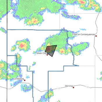
 FLOOD ADVISORY IN EFFECT UNTIL 9 PM MDT THIS EVENING...
* WHAT...Flooding caused by excessive rainfall is expected.
* WHERE...A portion of southwest New Mexico, including the following county, Grant.
* WHEN...Until 900 PM MDT.
* IMPACTS...Minor flooding in low-lying and poor drainage areas. Some low-water crossings may become impassable.
* ADDITIONAL DETAILS...
- At 658 PM MDT, Doppler radar indicated heavy rain due to thunderstorms. Minor flooding is ongoing or expected to begin shortly in the advisory area. Up to 1.5 inches of rain have fallen.
- Category: Weather
 FLOOD ADVISORY IN EFFECT UNTIL 815 PM MDT THIS EVENING...
* WHAT...Flooding caused by excessive rainfall is expected.
* WHERE...A portion of southwest New Mexico, including the following county, Grant.
* WHEN...Until 815 PM MDT.
* IMPACTS...Minor flooding in low-lying and poor drainage areas.
Some low-water crossings may become impassable.
* ADDITIONAL DETAILS...
- At 614 PM MDT, Doppler radar indicated heavy rain due to thunderstorms. Minor flooding is ongoing or expected to begin shortly in the advisory area. Up to 1 inch of rain has
fallen.
- Category: Weather
If it's raining and coming your way, there might be a flood advisory!
 FLOOD ADVISORY IN EFFECT UNTIL 830 PM MDT THIS EVENING...
* WHAT...Flooding caused by excessive rainfall is expected.
* WHERE...A portion of southwest New Mexico, including the following
county, Grant.
* WHEN...Until 730 PM MDT.
* IMPACTS...Minor flooding in low-lying and poor drainage areas.
Some low-water crossings may become impassable.
* ADDITIONAL DETAILS...
- At 538 PM MDT, Doppler radar indicated heavy rain due to thunderstorms. Minor flooding is ongoing or expected to begin shortly in the advisory area. Up to 1.5 inches of rain have fallen.
- Category: Weather
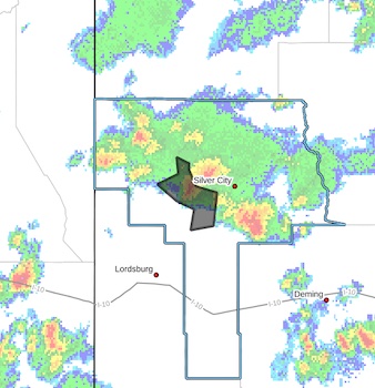
Just in case, you can't hear the thunder and wind or aren't looking out a window, there's a strong thunderstorm in NE Grant County
 A STRONG THUNDERSTORM WILL IMPACT NORTHEASTERN GRANT COUNTY
THROUGH 530 PM MDT...
At 505 PM MDT, Doppler radar was tracking a strong thunderstorm over
Pinos Altos, moving east at 15 mph.
HAZARD...Wind gusts up to 50 mph and half inch hail.
SOURCE...Radar indicated.
IMPACT...Gusty winds could knock down tree limbs and blow around
unsecured objects. Minor hail damage to vegetation is
possible.
- Category: Weather
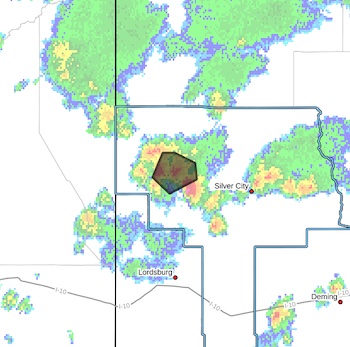
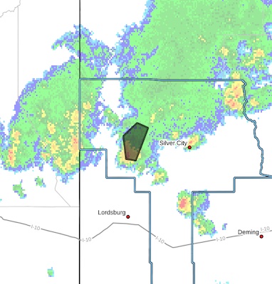
The flash flood warning is primarily over the Trout Burn scar. If you live there, you know where it is.
 Flash Flood Warning
National Weather Service El Paso Tx/Santa Teresa NM
449 PM MDT Thu Jul 31 2025
The National Weather Service in El Paso Tx/Santa Teresa has issued a
* Flash Flood Warning for...
The Trout Fire Burn Scar in...
Northeastern Grant County in southwestern New Mexico...
* Until 700 PM MDT.
- Category: Weather
HIGH WIND WEATHER ADVISORY:
High wind warning in Hildago County, visibility is low in areas due to blowing dust. High profile vehicles please use caution. The NMDOT will continue monitoring the roadway. This event will be updated as conditions change
[Editor's Note: Since this happens almost every day, do we still need to post this? How about just being prepared for high wind and low visibility almost every afternoon!]
- Category: Weather
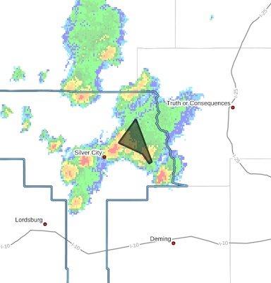
 FLOOD ADVISORY IN EFFECT UNTIL 1030 PM MDT THIS EVENING...
* WHAT...Arroyo and small stream flooding caused by excessive
rainfall is expected.
* WHERE...A portion of southwest New Mexico, including the following county, Grant.
* WHEN...Until 1030 PM MDT.
* IMPACTS...Minor flooding in low-lying and poor drainage areas.
* ADDITIONAL DETAILS...
- At 721 PM MDT, Doppler radar indicated heavy rain due to
thunderstorms. This will cause arroyo and small stream flooding. Up to 1 inch of rain has fallen.
- Category: Weather
FLOODING – Deming/Columbus Area
Difficult Driving Conditions, NM 9 eastbound and westbound at mile marker 93, 4 miles east of Columbus. Standing water on roadway. Use extreme caution.
When the roadway is flooded do not cross and seek an alternate route. Turn around, don’t drown.


Content on the Beat
WARNING: All articles and photos with a byline or photo credit are copyrighted to the author or photographer. You may not use any information found within the articles without asking permission AND giving attribution to the source. Photos can be requested and may incur a nominal fee for use personally or commercially.
Disclaimer: If you find errors in articles not written by the Beat team but sent to us from other content providers, please contact the writer, not the Beat. For example, obituaries are always provided by the funeral home or a family member. We can fix errors, but please give details on where the error is so we can find it. News releases from government and non-profit entities are posted generally without change, except for legal notices, which incur a small charge.
NOTE: If an article does not have a byline, it was written by someone not affiliated with the Beat and then sent to the Beat for posting.
Images: We have received complaints about large images blocking parts of other articles. If you encounter this problem, click on the title of the article you want to read and it will take you to that article's page, which shows only that article without any intruders.
New Columnists: The Beat continues to bring you new columnists. And check out the old faithfuls who continue to provide content.
Newsletter: If you opt in to the Join GCB Three Times Weekly Updates option above this to the right, you will be subscribed to email notifications with links to recently posted articles.
Editor's Notes
It has come to this editor's attention that people are sending information to the Grant County Beat Facebook page. Please be aware that the editor does not regularly monitor the page. If you have items you want to send to the editor, please send them to editor@grantcountybeat.com. Thanks!
Here for YOU: Consider the Beat your DAILY newspaper for up-to-date information about Grant County. It's at your fingertips! One Click to Local News. Thanks for your support for and your readership of Grant County's online news source—www.grantcountybeat.com
Feel free to notify editor@grantcountybeat.com if you notice any technical problems on the site. Your convenience is my desire for the Beat. The Beat totally appreciates its readers and subscribers!
Compliance: Because you are an esteemed member of The Grant County Beat readership, be assured that we at the Beat continue to do everything we can to be in full compliance with GDPR and pertinent US law, so that the information you have chosen to give to us cannot be compromised.
Submitting to the Beat
Those new to providing news releases to the Beat are asked to please check out submission guidelines at https://www.grantcountybeat.com/about/submissions. They are for your information to make life easier on the readers, as well as for the editor.
Advertising: Don't forget to tell advertisers that you saw their ads on the Beat.
Classifieds: We have changed Classifieds to a simpler option. Check periodically to see if any new ones have popped up. Send your information to editor@grantcountybeat.com and we will post it as soon as we can. Instructions and prices are on the page.