
Latest News


Wizard of Id Comic for November 1, 2024
Get the GCB Update
You'll receive the Update on Monday, Wednesday, and Friday.

- Category: Front Page News
By Lynn Janes
The town of Bayard held a regular meeting June 24, 2024. Attendance included Mayor John L. Ojinaga, Pro Tem Eloy Medina, councilors, Eloy Gonzales, Frances Gonzales and Gilbert Ortiz. Martha Salas, city clerk/treasurer also attended.
The council approved the consent agenda. It included attendance to the municipal officials leadership institute, police report May 2024, first line supervisors course for Trevor Jensen, wastewater treatment report May 2024, accounts payable June 24, 2024, and minutes for meeting June 10, 2024.
Old business
- Category: Weather
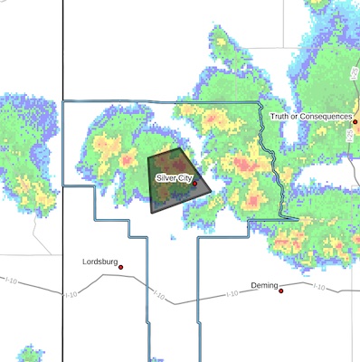
 STRONG THUNDERSTORMS WILL IMPACT NORTH CENTRAL GRANT COUNTY
THROUGH 530 PM MDT...
At 457 PM MDT, Doppler radar was tracking a cluster of strong
thunderstorms 6 miles east of Mangas Springs, moving southeast at 20
mph.
HAZARD...Wind gusts up to 50 mph and penny size hail.
SOURCE...Radar indicated.
- Category: Weather
BULLETIN - IMMEDIATE BROADCAST REQUESTED
Severe Thunderstorm Warning
National Weather Service El Paso TX
351 PM MDT Tue Jul 9 2024
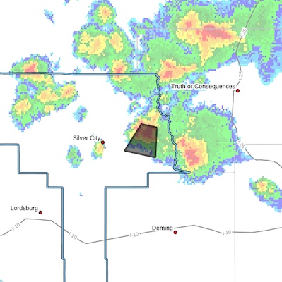
 The National Weather Service in El Paso has issued a
* Severe Thunderstorm Warning for...
East central Grant County in southwestern New Mexico...
* Until 430 PM MDT.
* At 350 PM MDT, a severe thunderstorm was located over Mimbres,
moving south at 15 mph.
HAZARD...60 mph wind gusts and half dollar size hail.
SOURCE...Radar indicated.
- Category: Front Page News
QUEMADO, NM, ?July 9, 2024 – The Lolo Fire transitioned to a type 3 incident management team on Monday and is estimated at 378 acres in the Quemado Ranger District. The fire is located between Escondido Mountain and the Continental Divide Trail, roughly 6 miles northeast of Quemado Lake.
"Currently, there are no area closures in place for the fire," said Quemado District Ranger Randall Chavez. "But for the safety of the public and crews, we would appreciate it if they would avoid the immediate area for firefighting efforts."
- Category: Front Page News
?MIMBRES, NM, July 9, 2024 – The Ridge Fire is approximately 1,100 acres burning in the Gila National Forest, Wilderness Ranger District. One to two-foot flames lengths were observed yesterday as the fire burns in an old fire scar, moving through grass, needle cast, and dead and downed logs. Crews began assessing private residences as they plan for potential structure protection yesterday. Gusty winds and lightning in today's weather forecast may hinder crews who have been conducting prep work on trails and roads that will be used as holding features in future operations.
"Currently, there are no area closures, but we anticipate some areas being impacted when the Complex Incident Management Team assumes command in the coming days," said Silver City District Ranger Elizabeth Toney. "As always, firefighter and public safety is our top priority, and we advise the public to avoid the fire area both on the ground and in the air."
Content on the Beat
WARNING: All articles and photos with a byline or photo credit are copyrighted to the author or photographer. You may not use any information found within the articles without asking permission AND giving attribution to the source. Photos can be requested and may incur a nominal fee for use personally or commercially.
Disclaimer: If you find errors in articles not written by the Beat team but sent to us from other content providers, please contact the writer, not the Beat. For example, obituaries are always provided by the funeral home or a family member. We can fix errors, but please give details on where the error is so we can find it. News releases from government and non-profit entities are posted generally without change, except for legal notices, which incur a small charge.
NOTE: If an article does not have a byline, it was written by someone not affiliated with the Beat and then sent to the Beat for posting.
Images: We have received complaints about large images blocking parts of other articles. If you encounter this problem, click on the title of the article you want to read and it will take you to that article's page, which shows only that article without any intruders.
New Columnists: The Beat continues to bring you new columnists. And check out the old faithfuls who continue to provide content.
Newsletter: If you opt in to the Join GCB Three Times Weekly Updates option above this to the right, you will be subscribed to email notifications with links to recently posted articles.
Editor's Notes
It has come to this editor's attention that people are sending information to the Grant County Beat Facebook page. Please be aware that the editor does not regularly monitor the page. If you have items you want to send to the editor, please send them to editor@grantcountybeat.com. Thanks!
Here for YOU: Consider the Beat your DAILY newspaper for up-to-date information about Grant County. It's at your fingertips! One Click to Local News. Thanks for your support for and your readership of Grant County's online news source—www.grantcountybeat.com
Feel free to notify editor@grantcountybeat.com if you notice any technical problems on the site. Your convenience is my desire for the Beat. The Beat totally appreciates its readers and subscribers!
Compliance: Because you are an esteemed member of The Grant County Beat readership, be assured that we at the Beat continue to do everything we can to be in full compliance with GDPR and pertinent US law, so that the information you have chosen to give to us cannot be compromised.
Submitting to the Beat
Those new to providing news releases to the Beat are asked to please check out submission guidelines at https://www.grantcountybeat.com/about/submissions. They are for your information to make life easier on the readers, as well as for the editor.
Advertising: Don't forget to tell advertisers that you saw their ads on the Beat.
Classifieds: We have changed Classifieds to a simpler option. Check periodically to see if any new ones have popped up. Send your information to editor@grantcountybeat.com and we will post it as soon as we can. Instructions and prices are on the page.


