

 Click to Search
Search
{{#data.error.root_cause}}
{{/data.error}}
{{^data.error}}
[{{{type}}}] {{{reason}}}
{{/data.error.root_cause}}
{{#data.hits.hits}}
{{#_source.featured}}
FEATURED
{{/_source.featured}}
{{#_source.showImage}}
{{#_source.image}}
 {{/_source.image}}
{{/_source.showImage}}
{{/_source.image}}
{{/_source.showImage}}
{{/data.hits.hits}}
{{{_source.title}}} {{#_source.showPrice}} {{{_source.displayPrice}}} {{/_source.showPrice}}
{{#_source.showLink}} {{/_source.showLink}} {{#_source.showDate}}{{{_source.displayDate}}}
{{/_source.showDate}}{{{_source.description}}}
{{#_source.additionalInfo}}{{#_source.additionalFields}} {{#title}} {{{label}}}: {{{title}}} {{/title}} {{/_source.additionalFields}}
{{/_source.additionalInfo}}
Latest News


Subscribe to the Update
- Category: Front Page News
Gila National Forest
https://www.fs.usda.gov/r03/gila
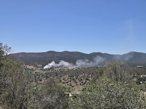
Hummingbird Fire Update
Final update for the Hummingbird Fire
(Silver City, NM, May 30, 2026) —A four-person wildland-engine crew continues to patrol the Hummingbird Fire. Containment is 90%, and the size remains 5,716 acres. The lightning-caused wildfire is located 15 miles east of Glenwood, NM in the Gila Wilderness.
The uncontained portion of the fire is in the Iron Creek area on the fire's southern perimeter. The Bearwallow Mountain lookout has a clear view into the Iron Creek drainage; no smoke has been observed in this area for several days, and fire managers do not anticipate that the fire will spread. However, due to the many hazards in the Iron Creek area, including steep and rugged terrain; numerous standing and downed dead trees; and long evacuation times in case of injury, firefighters are utilizing an indirect confinement strategy on this portion of the perimeter. Firefighter and public safety remain the number one objective for the Hummingbird Fire.
- Category: Front Page News

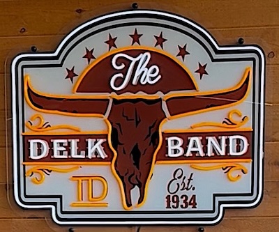 Tyce Delk, the great-grandson of Forrest Delk, who founded the Delk Band in 1934, right here in Grant County, has received an invitation to debut at the Grand Ole Opry in Nashville, Tennessee on July 16, 2026
Grant County enjoyed The Delk Band from its founding by Forrest Delk in 1934. Although the band plays on in eastern New Mexico, many of today's residents danced and sang along with The Delk Band for many years.
Please see the PDF below to read all about how Tyce found out about the invitation and learned that today's The Delk Band will perform along with him.
- Category: Front Page News
By Roger Lanse
According to Silver City Fire Department personnel, at roughly 4:10 p.m. Wednesday, May 27. 2026, Grant County fire suppression crews are engaged in fighting a large residential structure blaze with heavy smoke, on Emerald Drive off of Cottage San Road
Agencies involved are SCFD; Pinos Altos, Tyrone, Whiskey Creek, and Fort Bayard volunteer fire departments; and New Mexico State Police.
At this time, the house reportedly was so engulfed it seemed ready to collapse.
No injuries have been reported.
[Editor's Note: See Photos at https://www.grantcountybeat.com/home/news-articles/photos-of-fire-in-silver-city-052726
- Category: Front Page News
Photos of a fire in Silver City courtesy of Saul Osuna.
[Editor's Note: We have not yet been able to get information on where it is. We will add when we have it.]
- Category: Front Page News
By Lynn Janes
The Silver City Town Council held a regular meeting May 12, 2026. Attendance to the meeting included Mayor Simon Wheaton-Smith, Nicholas Prince, Stan Snider, Victor Nanez and Angela Salaiz.
The council approved the agenda.
Ceremonies
Jacqui Olea, assistant town manager, presented the employee of the month award to Johnathan Baca. He had stepped up to the role of acting utility supervisor and is a pillar of the team. Often, he will be the first to volunteer to help colleagues struggling with a heavy workload.
Proclamations
The town proclaimed Wild Wild West Rodeo Days June 5 and 6, 2026. This will be the 34th year in Silver City. Kim Clark attended to receive the proclamation.
- Category: Front Page News
By Lynn Janes
The town of Hurley had a workshop and regular meeting May 12, 2026. Reynaldo Maynes, Ester Gil and Robert Candelaria attended. Aron Phillips and Jason Cox did not attend.
The council held a workshop to review the 2026-2027 budget. Darlene McBride, town clerk, provided them with the current budget and the proposed budget for the next fiscal year. She had included requests from the different departments. Kevin Vigil presented the requests he had for the police department. It had included increases in pay and clothing allowance. He went over the requests in detail. Maynes had some questions Vigil answered and clarified.
Workshop meeting adjourned
Regular meeting
Phillips joined the meeting online.
Public input
Page 11 of 180


Content on the Beat
WARNING: All articles and photos with a byline or photo credit are copyrighted to the author or photographer. You may not use any information found within the articles without asking permission AND giving attribution to the source. Photos can be requested and may incur a nominal fee for use personally or commercially.
Disclaimer: If you find errors in articles not written by the Beat team but sent to us from other content providers, please contact the writer, not the Beat. For example, obituaries are always provided by the funeral home or a family member. We can fix errors, but please give details on where the error is so we can find it. News releases from government and non-profit entities are posted generally without change, except for legal notices, which incur a small charge.
NOTE: If an article does not have a byline, it was written by someone not affiliated with the Beat and then sent to the Beat for posting.
Images: We have received complaints about large images blocking parts of other articles. If you encounter this problem, click on the title of the article you want to read and it will take you to that article's page, which shows only that article without any intruders.
New Columnists: The Beat continues to bring you new columnists. And check out the old faithfuls who continue to provide content.
Newsletter: If you opt in to the Join GCB Three Times Weekly Updates option above this to the right, you will be subscribed to email notifications with links to recently posted articles.
Editor's Notes
It has come to this editor's attention that people are sending information to the Grant County Beat Facebook page. Please be aware that the editor does not regularly monitor the page. If you have items you want to send to the editor, please send them to editor@grantcountybeat.com. Thanks!
Here for YOU: Consider the Beat your DAILY newspaper for up-to-date information about Grant County. It's at your fingertips! One Click to Local News. Thanks for your support for and your readership of Grant County's online news source—www.grantcountybeat.com
Feel free to notify editor@grantcountybeat.com if you notice any technical problems on the site. Your convenience is my desire for the Beat. The Beat totally appreciates its readers and subscribers!
Compliance: Because you are an esteemed member of The Grant County Beat readership, be assured that we at the Beat continue to do everything we can to be in full compliance with GDPR and pertinent US law, so that the information you have chosen to give to us cannot be compromised.
Submitting to the Beat
Those new to providing news releases to the Beat are asked to please check out submission guidelines at https://www.grantcountybeat.com/about/submissions. They are for your information to make life easier on the readers, as well as for the editor.
Advertising: Don't forget to tell advertisers that you saw their ads on the Beat.
Classifieds: We have changed Classifieds to a simpler option. Check periodically to see if any new ones have popped up. Send your information to editor@grantcountybeat.com and we will post it as soon as we can. Instructions and prices are on the page.