

 Click to Search
Search
[{{{type}}}] {{{reason}}}
{{/data.error.root_cause}}
{{{_source.title}}} {{#_source.showPrice}} {{{_source.displayPrice}}} {{/_source.showPrice}}
{{#_source.showLink}} {{/_source.showLink}} {{#_source.showDate}}{{{_source.displayDate}}}
{{/_source.showDate}}{{{_source.description}}}
{{#_source.additionalInfo}}{{#_source.additionalFields}} {{#title}} {{{label}}}: {{{title}}} {{/title}} {{/_source.additionalFields}}
{{/_source.additionalInfo}}
Weather
- Category: Weather
FLOODING – Animas Area
Difficult Driving Conditions, NM 9 eastbound and westbound from mile marker 1 to mile marker 2, 2 mile east of Arizona Stateline. Standing water on roadway. Use extreme caution.
When the roadway is flooded do not cross and seek an alternate route. Turn around, don't drown.
- Category: Weather
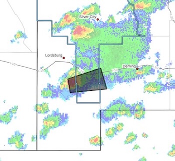 Severe Thunderstorm Warning
National Weather Service El Paso TX
319 PM MDT Sat Sep 13 2025
The National Weather Service in El Paso has issued a
* Severe Thunderstorm Warning for...
South central Grant County in southwestern New Mexico... West central Luna County in southwestern New Mexico... Central Hidalgo County in southwestern New Mexico...
* Until 400 PM MDT.
* At 319 PM MDT, a severe thunderstorm was located 9 miles northeast
of Windmill, moving east at 35 mph.
- Category: Weather
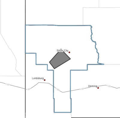 Severe Thunderstorm Warning
National Weather Service El Paso TX
314 PM MDT Sat Sep 13 2025
The National Weather Service in El Paso has issued a
* Severe Thunderstorm Warning for...
Central Grant County in southwestern New Mexico...
* Until 400 PM MDT.
* At 314 PM MDT, a severe thunderstorm was located 4 miles southwest of Oak Grove, moving northeast at 40 mph.
HAZARD...60 mph wind gusts and quarter size hail.
SOURCE...Radar indicated.
- Category: Weather
ROAD ADVISORY
FLOODING – Virden Area
NM 92 from milepost 0 to 6 has water running over the roadway at low water crossings, roadway is still passable. NMDOT is currently monitoring and will notify as conditions change.
ROAD ADVISORY
FLOODING – Road Forks Area
- Category: Weather
NM 15 is now clear from mile marker 24 to 25, removed from NM Roads.
ROAD ADVISORY:
ALERT – CLIFF DWELLINGS AREA
Alert, NM 15 northbound and southbound from mile marker 24, to mile marker 25, debris in road, NMDOT in route.
- Category: Weather
ROAD CLOSURE
Animas/Cotton City Area
NM 145 "Goat Camp Rd" is closed from milepost 1 to milepost 3 (NM 338) due to roadway not suitable for travel at this time. Only local residents will be permitted. NMDOT is currently monitoring and will notify as conditions change.
- Category: Weather
ROAD ADVISORY:
Fair Driving Conditions- Lordsburg Area
Fair Driving Conditions, I 10 eastbound and westbound from mile marker 0, Arizona State Line to mile marker 20, (LORDSBURG WEST). Roads are wet and may become slick. Cloudy and windy conditions may result in reduced visibility, use caution and reduce speeds.
- Category: Weather
Attached is the NWS Situational Awareness Briefing for the potential rainfall impacts from the moisture associated with Hurricane Lorena. Hurricane Lorena is expected to weaken as it moves up the west coast of Baja California, stalls, and likely never makes landfall. Rainfall estimates have been trending downward with no flood watches in effect or expected.

Western Bank holiday hours 2025


Content on the Beat
WARNING: All articles and photos with a byline or photo credit are copyrighted to the author or photographer. You may not use any information found within the articles without asking permission AND giving attribution to the source. Photos can be requested and may incur a nominal fee for use personally or commercially.
Disclaimer: If you find errors in articles not written by the Beat team but sent to us from other content providers, please contact the writer, not the Beat. For example, obituaries are always provided by the funeral home or a family member. We can fix errors, but please give details on where the error is so we can find it. News releases from government and non-profit entities are posted generally without change, except for legal notices, which incur a small charge.
NOTE: If an article does not have a byline, it was written by someone not affiliated with the Beat and then sent to the Beat for posting.
Images: We have received complaints about large images blocking parts of other articles. If you encounter this problem, click on the title of the article you want to read and it will take you to that article's page, which shows only that article without any intruders.
New Columnists: The Beat continues to bring you new columnists. And check out the old faithfuls who continue to provide content.
Newsletter: If you opt in to the Join GCB Three Times Weekly Updates option above this to the right, you will be subscribed to email notifications with links to recently posted articles.
Editor's Notes
It has come to this editor's attention that people are sending information to the Grant County Beat Facebook page. Please be aware that the editor does not regularly monitor the page. If you have items you want to send to the editor, please send them to editor@grantcountybeat.com. Thanks!
Here for YOU: Consider the Beat your DAILY newspaper for up-to-date information about Grant County. It's at your fingertips! One Click to Local News. Thanks for your support for and your readership of Grant County's online news source—www.grantcountybeat.com
Feel free to notify editor@grantcountybeat.com if you notice any technical problems on the site. Your convenience is my desire for the Beat. The Beat totally appreciates its readers and subscribers!
Compliance: Because you are an esteemed member of The Grant County Beat readership, be assured that we at the Beat continue to do everything we can to be in full compliance with GDPR and pertinent US law, so that the information you have chosen to give to us cannot be compromised.
Submitting to the Beat
Those new to providing news releases to the Beat are asked to please check out submission guidelines at https://www.grantcountybeat.com/about/submissions. They are for your information to make life easier on the readers, as well as for the editor.
Advertising: Don't forget to tell advertisers that you saw their ads on the Beat.
Classifieds: We have changed Classifieds to a simpler option. Check periodically to see if any new ones have popped up. Send your information to editor@grantcountybeat.com and we will post it as soon as we can. Instructions and prices are on the page.