



 Click to Search
Search
[{{{type}}}] {{{reason}}}
{{/data.error.root_cause}}
{{{_source.title}}} {{#_source.showPrice}} {{{_source.displayPrice}}} {{/_source.showPrice}}
{{#_source.showLink}} {{/_source.showLink}} {{#_source.showDate}}{{{_source.displayDate}}}
{{/_source.showDate}}{{{_source.description}}}
{{#_source.additionalInfo}}{{#_source.additionalFields}} {{#title}} {{{label}}}: {{{title}}} {{/title}} {{/_source.additionalFields}}
{{/_source.additionalInfo}}


Weather
- Category: Weather
NM 92 is now clear. Removed from NM Roads.
ROAD ADVISORY
FAIR DRIVING CONDITIONS – Lordsburg Area
Fair Driving Conditions, NM 92 eastbound and westbound from mile marker 0, Arizona State Line to mile marker 6, 3 miles east of Virden. Debris on road, crew is on site clearing.
[Editor's Note: From dust storm to flooding - just to make things interesting, I guess. Be prepared for crazy weather and maybe, just maybe we should ignore the alerts that come without end. Trying to scare us maybe? It's the weather folks, and it does not pay attention to those who predict it!]
ROAD ADVISORY
CLOSURE – Lordsburg Area
Closure, NM 92 eastbound and westbound from mile marker 0, Arizona State Line to mile marker 6, 3 miles east of Virden is closed due to flooding. Roadways are not passable. Do not attempt to cross. The NMDOT is currently clearing roadway and will notify as conditions change.
When the roadway is flooded do not cross and seek an alternate route. Turn around, don’t drown.
- Category: Weather
[Editor's Note: Guess what? It's your regular daily afternoon high wind weather advisory for Hidalgo County. Please realize this happens just about every afternoon this time of year. Sometime it has rain with it; sometimes it doesn't. Be prepared! Stay Safe! Don't except any more of these, unless they are different!]
HIGH WIND WEATHER ADVISORY:
High wind warning in Hildago County. High profile vehicles please use caution. The NMDOT will continue monitoring the roadway. This event will be updated as conditions change.
- Category: Weather
[Editor's Note: I've gotten three weather alerts on severe thunderstorms rolling through Grant County. More may come. Posting just one takes up to 5 minutes per event. And I have decided that it is not worth my time.
I'm guessing many of you have weather apps on your phone or computer and they predict when weather events are "likely" to arrive in your area. After all, it is monsoon season, and you know if you live n a flood prone area or not and likely keep an eye on the sky.
I will continue to post ones that cover more general areas and are received on the previous dates, so that you can see prepare with alerts on the Beat.
May I request that you , and I know you are smart , figure out your own preparation for wild weather.
Stay safe!]
If you protest this decision, please email me at
- Category: Weather
FLOODING – Glenwood Area
Difficult Driving Conditions, NM 174 eastbound and westbound lanes from mile marker 0 to 4, all low water crossings are running with debris. Use extreme caution.
When the roadway is flooded do not cross and seek an alternate route. Turn around, don't drown.
- Category: Weather
Attached is a Situational Awareness Briefing for the potential for heavy rain and flash flooding over south-central NM, on Saturday, August 1st:
· Scattered to numerous thunderstorms developing Saturday afternoon and evening, progressing from north to south
· Multiple rounds of storms possible with rainfall up to 2-3"
· Wind gusts over 60 mph and large hail are possible as well.
- Category: Weather
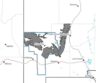 Upper Gila River Valley-Southern Gila Foothills/Mimbres Valley-
Eastern Black Range Foothills-
Including the cities of Hurley, Buckhorn, Grant County Airport,
Hillsboro, Mule Creek, Gila Hot Springs, Winston, Faywood, and
Cliff
1039 AM MDT Thu Jul 30 2026
...HEAT ADVISORY IN EFFECT FROM 10 AM TO 9 PM MDT FRIDAY...
* WHAT...Temperatures of 99 to 102 expected.
* WHERE...Eastern Black Range Foothills, Southern Gila
Foothills/Mimbres Valley, and Upper Gila River Valley.
* WHEN...From 10 AM to 9 PM MDT Friday.
* IMPACTS...Hot temperatures may cause heat illnesses.
- Category: Weather
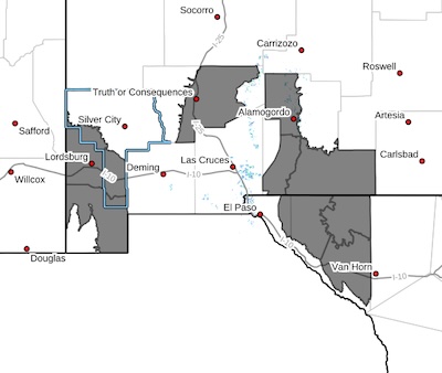 Southwest Desert/Mimbres Basin-Northern Dona Ana County-Southern Dona Ana County/Mesilla Valley-West Central Tularosa Basin/White Sands-
Including the cities of Chaparral, Radium Springs, Las Cruces,
Sunland Park, Garfield, White Sands Range Headquarters, Vado, Hatch, Deming, Columbus, and White Sands National Park
1018 PM MDT Wed Jul 29 2026
...HEAT ADVISORY IN EFFECT UNTIL 9 PM MDT FRIDAY...
* WHAT...Hot temperatures 103 to 107 degrees expected.
* WHERE...Portions of Far West Texas, including El Paso County and
the lower Rio Grande Valley in Hudspeth County. Portions of
southwest New Mexico, including Dona Ana and Luna Counties and the
western Tularosa Basin.
* WHEN...Until 9 PM MDT Friday.
- Category: Weather
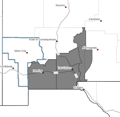 Southwest Desert/Mimbres Basin-Northern Dona Ana County-Southern Dona Ana County/Mesilla Valley-West Central Tularosa Basin/White Sands-
Including the cities of Chaparral, Radium Springs, Las Cruces,
Sunland Park, Garfield, White Sands Range Headquarters, Vado, Hatch, Deming, Columbus, and White Sands National Park
1018 PM MDT Wed Jul 29 2026
...HEAT ADVISORY IN EFFECT UNTIL 9 PM MDT FRIDAY...
* WHAT...Hot temperatures 103 to 107 degrees expected.
* WHERE...Portions of Far West Texas, including El Paso County and
the lower Rio Grande Valley in Hudspeth County. Portions of
southwest New Mexico, including Dona Ana and Luna Counties and the
western Tularosa Basin.
* WHEN...Until 9 PM MDT Friday.





Content on the Beat
WARNING: All articles and photos with a byline or photo credit are copyrighted to the author or photographer. You may not use any information found within the articles without asking permission AND giving attribution to the source. Photos can be requested and may incur a nominal fee for use personally or commercially.
Disclaimer: If you find errors in articles not written by the Beat team but sent to us from other content providers, please contact the writer, not the Beat. For example, obituaries are always provided by the funeral home or a family member. We can fix errors, but please give details on where the error is so we can find it. News releases from government and non-profit entities are posted generally without change, except for legal notices, which incur a small charge.
NOTE: If an article does not have a byline, it was written by someone not affiliated with the Beat and then sent to the Beat for posting.
Images: We have received complaints about large images blocking parts of other articles. If you encounter this problem, click on the title of the article you want to read and it will take you to that article's page, which shows only that article without any intruders.
New Columnists: The Beat continues to bring you new columnists. And check out the old faithfuls who continue to provide content.
Newsletter: If you opt in to the Join GCB Three Times Weekly Updates option above this to the right, you will be subscribed to email notifications with links to recently posted articles.
Editor's Notes
It has come to this editor's attention that people are sending information to the Grant County Beat Facebook page. Please be aware that the editor does not regularly monitor the page. If you have items you want to send to the editor, please send them to editor@grantcountybeat.com. Thanks!
Here for YOU: Consider the Beat your DAILY newspaper for up-to-date information about Grant County. It's at your fingertips! One Click to Local News. Thanks for your support for and your readership of Grant County's online news source—www.grantcountybeat.com
Feel free to notify editor@grantcountybeat.com if you notice any technical problems on the site. Your convenience is my desire for the Beat. The Beat totally appreciates its readers and subscribers!
Compliance: Because you are an esteemed member of The Grant County Beat readership, be assured that we at the Beat continue to do everything we can to be in full compliance with GDPR and pertinent US law, so that the information you have chosen to give to us cannot be compromised.
Submitting to the Beat
Those new to providing news releases to the Beat are asked to please check out submission guidelines at https://www.grantcountybeat.com/about/submissions. They are for your information to make life easier on the readers, as well as for the editor.
Advertising: Don't forget to tell advertisers that you saw their ads on the Beat.
Classifieds: We have changed Classifieds to a simpler option. Check periodically to see if any new ones have popped up. Send your information to editor@grantcountybeat.com and we will post it as soon as we can. Instructions and prices are on the page.